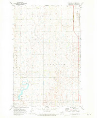
1971 Map of Big Coulee Dam
USGS Topo · Published 1973About this map
Big Coulee Dam and its associated recreation area anchor the southwestern portion of this Towner County landscape, where the Big Coulee waterway is managed for local water resources. The terrain is characterized by the prairie pothole region's distinctive wetland depressions, stretching across the townships of Howell, Grainfield, Sorenson, and Gerrard. Along the southern edge, the Soo Line railroad connects the small settlements of Bisbee and New City, serving as a vital transportation artery for this agricultural interior.
Find a feature on this map
20 named features on this map. Tap any name to fly to it.
Don’t see what you’re looking for? This feature index may not catch every label — zoom into the map to look around manually.
Map Details
Editions of this 1971 Big Coulee Dam Map
This is the sole edition of this map. No revisions or reprints were ever made.
Other maps of this area

1953 · Devils Lake
USGS Topo · 1:250,000

1956 · Devils Lake
USGS Topo · 1:250,000

1962 · Egeland SW
USGS Topo · 1:24,000

1962 · Snyder Lake
USGS Topo · 1:24,000

1970 · Hansboro SW
USGS Topo · 1:24,000

1970 · Hansboro SE
USGS Topo · 1:24,000

1970 · Rock Lake
USGS Topo · 1:24,000

1971 · Bisbee South
USGS Topo · 1:24,000

1971 · Considine
USGS Topo · 1:24,000

1971 · Bisbee North
USGS Topo · 1:24,000