
1971 Map of Bisbee North
USGS Topo · Published 1973About this map
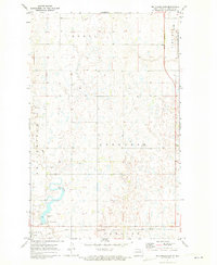
The Burlington Northern railroad corridor dictates the settlement pattern of this North Dakota prairie landscape, linking the small communities of Perth and Bisbee. This 1971 survey illustrates a highly organized agricultural grid, specifically within the township of Grainfield, where the land is dotted with countless small depressions and water bodies typical of the region's glacial topography. Local civic life is anchored by landmarks like the Townhall and the Bisbee Cem, while industrial activity is represented by a Gravel Pit and an electrical Substation. The boundary between Towner and Rolette counties bisects the terrain, which is further defined by the winding course of the Big Coulee and local sites like Lyster Field.
Find a feature on this map
16 named features on this map. Tap any name to fly to it.
Don’t see what you’re looking for? This feature index may not catch every label — zoom into the map to look around manually.
Map Details
Editions of this 1971 Bisbee North Map
This is the sole edition of this map. No revisions or reprints were ever made.
Other maps of this area

1953 · Devils Lake
USGS Topo · 1:250,000

1956 · Devils Lake
USGS Topo · 1:250,000

1970 · Hansboro SW
USGS Topo · 1:24,000

1970 · Hansboro SE
USGS Topo · 1:24,000

1970 · Rolla
USGS Topo · 1:24,000

1971 · Bisbee South
USGS Topo · 1:24,000

1971 · Considine
USGS Topo · 1:24,000

1971 · Mylo
USGS Topo · 1:24,000
1971 · Big Coulee Dam
USGS Topo · 1:24,000

1971 · Mylo SE
USGS Topo · 1:24,000