
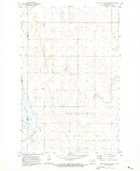
1971 Map of Mylo SE
USGS Topo · Published 1973About this map
Scattered wetlands and prairie depressions characterize this North Dakota landscape as it appeared in the early 1970s. The terrain is defined by the boundary between Rolette County and Pierce County, showing a rural township structure largely devoid of major settlements. Local history is anchored by the Mylo Cem in the north and the Pleasant Valley Cem further south, providing clear evidence of the area's rural burial grounds. The map reveals the local industry through several Gravel Pit and Gravel Pits sites, which are often the primary indicators of economic activity in this part of the plains. The intricate contour lines depict a complex network of potholes and small basins, typical of the glacial till plains that shape the regional agricultural potential and drainage patterns.
Find a feature on this map
5 named features on this map. Tap any name to fly to it.
Don’t see what you’re looking for? This feature index may not catch every label — zoom into the map to look around manually.
Map Details
Editions of this 1971 Mylo SE Map
This is the sole edition of this map. No revisions or reprints were ever made.
Other maps of this area

1953 · Devils Lake
USGS Topo · 1:250,000

1956 · Devils Lake
USGS Topo · 1:250,000

1971 · Wolford
USGS Topo · 1:24,000

1971 · Bisbee South
USGS Topo · 1:24,000

1971 · Island Lake
USGS Topo · 1:24,000

1971 · Mylo
USGS Topo · 1:24,000

1971 · Hurricane Lake West
USGS Topo · 1:24,000

1971 · Bisbee North
USGS Topo · 1:24,000

1971 · Mylo NW
USGS Topo · 1:24,000
1971 · Hurricane Lake East
USGS Topo · 1:24,000