
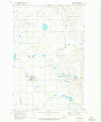
1971 Map of Mylo NW
USGS Topo · Published 1973About this map
Maryville and its surrounding prairie pothole landscape define this portion of Rolette County as it appeared in the early 1970s. The northern section of the map is dominated by the rural township-level organization, while the southern reaches are shaped by the waters of Long Lake. This area includes the Long Lake National Wildlife Refuge, which provides a protected environment for migratory waterfowl amid the intensive agricultural grid of the Great Plains. The Soo Line railroad cuts across the lower third of the quadrangle, passing just north of the Long Lake shoreline and serving as a vital transportation link for the region. Evidence of local industry is sparse but present, notably at a Gravel Pit located near the western edge of the refuge. The map also captures the Mylo Corporate Boundary, marking the legal limits of the nearby settlement at this specific point in time.
Find a feature on this map
6 named features on this map. Tap any name to fly to it.
Don’t see what you’re looking for? This feature index may not catch every label — zoom into the map to look around manually.
Map Details
Editions of this 1971 Mylo NW Map
This is the sole edition of this map. No revisions or reprints were ever made.
Other maps of this area

1936 · Lake Upsilon
USGS Topo · 1:48,000

1942 · Lake Upsilon
USGS Topo · 1:62,500

1953 · Devils Lake
USGS Topo · 1:250,000

1956 · Devils Lake
USGS Topo · 1:250,000

1968 · Lake Upsilon SE
USGS Topo · 1:24,000

1968 · Belcourt
USGS Topo · 1:24,000

1970 · Rolla
USGS Topo · 1:24,000

1971 · Island Lake
USGS Topo · 1:24,000

1971 · Mylo
USGS Topo · 1:24,000
1971 · Rolette
USGS Topo · 1:24,000