1971 Map of Rolette
USGS Topo · Published 1973About this map
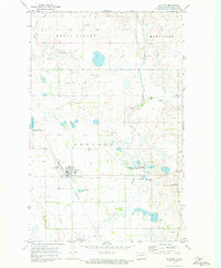
Rolette serves as a vital rail junction in north-central North Dakota, where the east-west tracks of the Soo Line intersect with the Burlington Northern railroad. This 1971 survey illustrates a prairie landscape defined by significant conservation areas, including the Ox Creek National Wildlife Refuge, Little Gurr Lake National Wildlife Refuge, and Long Lake National Wildlife Refuge. The terrain is divided into regional sections such as Shell Valley and Maryville, punctuated by glacial depressions and water bodies like Little Gurr Lake and Wolf Creek. Genealogists will find the locations of Rolette Cemetery and Westland Cemetery preserved here, while the presence of the Rolette Municipal Airport and a Sewage Disposal Pond reflects the town's mid-century infrastructure. Numerous Gravel Pits scattered across the township indicate the local extraction industry during this era.
Find a feature on this map
21 named features on this map. Tap any name to fly to it.
Don’t see what you’re looking for? This feature index may not catch every label — zoom into the map to look around manually.
Map Details
Editions of this 1971 Rolette Map
This is the sole edition of this map. No revisions or reprints were ever made.
Other maps of this area

1936 · Lake Upsilon
USGS Topo · 1:48,000

1942 · Lake Upsilon
USGS Topo · 1:62,500

1953 · Devils Lake
USGS Topo · 1:250,000

1955 · Thorne
USGS Topo · 1:24,000

1955 · Rolette SW
USGS Topo · 1:24,000

1955 · Lake Upsilon SW
USGS Topo · 1:24,000

1956 · Devils Lake
USGS Topo · 1:250,000

1968 · Lake Upsilon SE
USGS Topo · 1:24,000

1968 · Belcourt
USGS Topo · 1:24,000

1971 · Island Lake
USGS Topo · 1:24,000