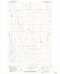
1971 Map of Hurricane Lake East
USGS Topo · Published 1973About this map
Hurricane Lake dominates the southwestern corner of this prairie landscape, straddling the border of Pierce Co and Towner Co during the early 1970s. The region is defined by the township divisions of Springfield and Zion, where a network of section lines and field boundaries reveals a rural economy centered on agriculture and small-scale resource extraction. Evidence of the local community's spiritual and ancestral roots is preserved through landmarks like North Prairie Ch, Wahl Cem, and Ostreim Cem, which serve as critical anchor points for genealogical research in this part of North Dakota. Numerous Gravel Pits are scattered across the terrain, indicating the practical industry of road building and maintenance in this glaciated environment.
Find a feature on this map
8 named features on this map. Tap any name to fly to it.
Don’t see what you’re looking for? This feature index may not catch every label — zoom into the map to look around manually.
Map Details
Editions of this 1971 Hurricane Lake East Map
This is the sole edition of this map. No revisions or reprints were ever made.
Other maps of this area

1953 · Devils Lake
USGS Topo · 1:250,000

1956 · Devils Lake
USGS Topo · 1:250,000

1971 · Bisbee South
USGS Topo · 1:24,000

1971 · Considine
USGS Topo · 1:24,000

1971 · Leeds NE
USGS Topo · 1:24,000

1971 · Hurricane Lake West
USGS Topo · 1:24,000

1971 · York
USGS Topo · 1:24,000

1971 · Leeds
USGS Topo · 1:24,000

1971 · Mylo SE
USGS Topo · 1:24,000
1971 · Niles
USGS Topo · 1:24,000