
1971 Map of York
USGS Topo · Published 1973About this map
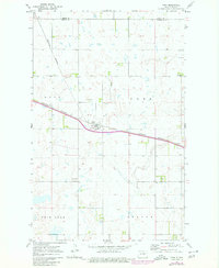
York serves as the primary hub of this prairie landscape, situated where the Burlington Northern railroad cuts through the heart of the region. The map highlights the interplay between agriculture and the natural prairie potholes that define this portion of the state, with the county line between Pierce Co and Benson Co dividing the northern townships. To the northwest, the edge of Rush Lake encroaches on the survey area, while scattered Gravel Pits suggest the local industrial activity of the early 1970s. The terrain is notably defined by distinct local divisions such as Knox, York, and Twin Lake, reflecting the township-oriented settlement patterns common to the North Dakota plains.
Find a feature on this map
9 named features on this map. Tap any name to fly to it.
Don’t see what you’re looking for? This feature index may not catch every label — zoom into the map to look around manually.
Map Details
Editions of this 1971 York Map
2 editions found
Other maps of this area

1953 · Devils Lake
USGS Topo · 1:250,000

1956 · Devils Lake
USGS Topo · 1:250,000

1957 · Comstock
USGS Topo · 1:24,000

1958 · Baker
USGS Topo · 1:24,000

1958 · Harlow
USGS Topo · 1:24,000

1971 · Wolford
USGS Topo · 1:24,000

1971 · Knox
USGS Topo · 1:24,000

1971 · Hurricane Lake West
USGS Topo · 1:24,000

1971 · Leeds
USGS Topo · 1:24,000
1971 · Hurricane Lake East
USGS Topo · 1:24,000