
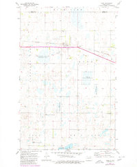
1971 Map of Knox
USGS Topo · Published 1973About this map
Knox serves as a central hub on the Burlington Northern railroad line in this early 1970s survey of the North Dakota prairie. The landscape is defined by a dense network of wetlands and conservation areas, including the Knox Slough State Game Management Area and several scattered federal preserves like the Wurgler National Wildlife Refuge and Carr National Wildlife Refuge. These areas reflect a concerted effort to manage the region's natural sloughs and water bodies, such as Pleasant Lake.
Find a feature on this map
19 named features on this map. Tap any name to fly to it.
Don’t see what you’re looking for? This feature index may not catch every label — zoom into the map to look around manually.
Map Details
Editions of this 1971 Knox Map
2 editions found
Other maps of this area

1953 · Devils Lake
USGS Topo · 1:250,000

1956 · Devils Lake
USGS Topo · 1:250,000

1958 · Fillmore
USGS Topo · 1:24,000

1958 · Baker
USGS Topo · 1:24,000

1958 · Harlow
USGS Topo · 1:24,000

1971 · Wolford
USGS Topo · 1:24,000

1971 · Rugby NE
USGS Topo · 1:24,000

1971 · Hurricane Lake West
USGS Topo · 1:24,000

1971 · York
USGS Topo · 1:24,000
1971 · Pleasant Lake
USGS Topo · 1:24,000