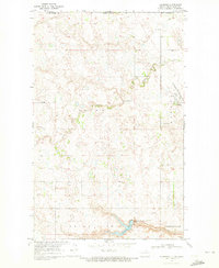
1969 Map of Hansboro
USGS Topo · Published 1972About this map
Hansboro sits as the primary settlement on this North Dakota landscape during the late 1960s, located just south of the international border where Canada and the United States meet. The area is characterized by the prairie potholes and drainage patterns of the Hidden Coulee, which winds through the townships of Picton and Sidney. The Burlington Northern railroad serves as the industrial lifeline for the town, connecting it to the broader grain-producing region. To the south, the terrain shifts towards the Armourdale Lake State Game Management Area, centered around Armourdale Lake. This survey by the U.S. Geological Survey and the State Water Commission captures a moment when the rural landscape was defined by section lines and small-scale infrastructure like the local Gaging Station and various Gravel Pit operations.
Find a feature on this map
14 named features on this map. Tap any name to fly to it.
Don’t see what you’re looking for? This feature index may not catch every label — zoom into the map to look around manually.
Map Details
Editions of this 1969 Hansboro Map
This is the sole edition of this map. No revisions or reprints were ever made.
Other maps of this area

1953 · Devils Lake
USGS Topo · 1:250,000

1956 · Devils Lake
USGS Topo · 1:250,000
1969 · Hansboro NE
USGS Topo · 1:24,000

1969 · Rolla NE
USGS Topo · 1:24,000

1970 · Hansboro SW
USGS Topo · 1:24,000

1970 · Hansboro SE
USGS Topo · 1:24,000

1970 · Rolla
USGS Topo · 1:24,000

1985 · Rock Lake
USGS Topo · 1:100,000
2011 · Hansboro SW
USGS Topo · 1:24,000
2011 · Rolla
USGS Topo · 1:24,000