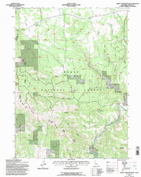
1993 Map of Happy Camp Mountain
USGS Topo · Published 1996About this map
Modoc National Forest encompasses this high-elevation terrain in northeastern California, where the Big Valley Ranger District and Devils Garden Ranger District meet. The landscape is defined by volcanic features and significant relief, anchored by the volcanic prominence of Happy Camp Mountain and the steep Noble Bluff. Evidence of early cattle ranching and settlement persists at the Old Hulbert Place and Log Corral Spring, points of interest for local historians tracking the development of this remote rangeland. The southern reaches are marked by the deeply incised Pit River canyon, featuring distinctive landmarks like Hanging Rock and Signal Rock. This 1993 revision, based on photographs from 1960 and 1988, shows a sophisticated network of forest roads like the Big Devils Garden Rd and the Valley Forge Route providing access through the timber and rimrock.
Find a feature on this map
39 named features on this map. Tap any name to fly to it.
Don’t see what you’re looking for? This feature index may not catch every label — zoom into the map to look around manually.
Map Details
Editions of this 1993 Happy Camp Mountain Map
This is the sole edition of this map. No revisions or reprints were ever made.
Other maps of this area

1886 · Alturas
USGS Topo · 1:250,000

1886 · Modoc Lava Bed
USGS Topo · 1:250,000

1892 · Modoc Lava-Bed
USGS Topo · 1:250,000

1892 · Alturas
USGS Topo · 1:250,000

1952 · Hackamore
USGS Topo · 1:62,500

1954 · Alturas
USGS Topo · 1:250,000

1958 · Alturas
USGS Topo · 1:250,000

1961 · Canby
USGS Topo · 1:62,500

1962 · Alturas
USGS Topo · 1:250,000

1962 · Crank Mountain
USGS Topo · 1:62,500