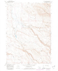
1967 Map of Happy Valley
USGS Topo · Published 1980About this map
Happy Valley and the high desert of Harney County are defined here by a network of seasonal water sources and isolated ranching operations. The Smyth Ranch and Riddle Ranch represent the human footprint in this arid landscape, supported by infrastructure like the Smyth Reservoir and various water points such as the Riddle Mtn Well and Thompson Well. Cultural history is evident in the presence of Pictographs along the canyon walls of Riddle Creek, pointing to an ancient presence long before the 20th-century cattle era. The terrain transitions from the open floor of Fisher Flat to the prominent heights of Riddle Mountain, while specific sites like The Lambing Ground and Ant Hill reflect localized ranching activities. For genealogists and local historians, the Smyth Cem and scattered Ruins provide concrete locations for tracing early families and settlement patterns in this part of Oregon.
Find a feature on this map
29 named features on this map. Tap any name to fly to it.
Don’t see what you’re looking for? This feature index may not catch every label — zoom into the map to look around manually.
Map Details
Editions of this 1967 Happy Valley Map
2 editions found
Other maps of this area

1955 · Burns
USGS Topo · 1:250,000

1955 · Adel
USGS Topo · 1:250,000

1957 · Adel
USGS Topo · 1:250,000

1958 · Burns
USGS Topo · 1:250,000

1958 · Adel
USGS Topo · 1:250,000

1959 · Burns
USGS Topo · 1:250,000

1962 · Adel
USGS Topo · 1:250,000

1967 · Happy Valley
USGS Topo · 1:24,000

1967 · Barton Lake
USGS Topo · 1:24,000

1967 · Diamond
USGS Topo · 1:24,000