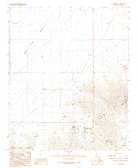
1990 Map of Harcuvar Peak
USGS Topo · Published 1990About this map
Harcuvar Mountains rise sharply above the floor of the Butler Valley, creating a landscape defined by dramatic elevation changes and mineral exploration. This 1990 survey captures the rugged interior of La Paz County, where a legacy of desert prospecting is evident in the numerous prospects, adits, and named mining claims scattered across the slopes. The presence of the Dolan Mine and Sheba Mine near the mountain crests suggests a history of small-scale extraction, likely targeting the veins exposed in the rocky crags surrounding Harcuvar Peak.
Find a feature on this map
23 named features on this map. Tap any name to fly to it.
Don’t see what you’re looking for? This feature index may not catch every label — zoom into the map to look around manually.
Map Details
Editions of this 1990 Harcuvar Peak Map
This is the sole edition of this map. No revisions or reprints were ever made.
Other maps of this area

1923 · Signal
USGS Topo · 1:250,000

1942 · Signal
USGS Topo · 1:250,000

1942 · Vicksburg
USGS Topo · 1:250,000

1950 · Prescott
USGS Topo · 1:250,000

1954 · Prescott
USGS Topo · 1:250,000

1954 · Phoenix
USGS Topo · 1:250,000

1957 · Phoenix
USGS Topo · 1:250,000

1958 · Prescott
USGS Topo · 1:250,000

1958 · Phoenix
USGS Topo · 1:250,000

1959 · Prescott
USGS Topo · 1:250,000