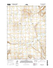
2017 Map of Hardin Ranch
USGS Topo · Published 2017About this map
Hardin Ranch serves as a central landmark in this high-desert landscape of Crook County, where water management defines the human presence. The area is characterized by a complex system of drainage and storage, from the seasonal flows of Twentymile Cr and Long Hollow Cr to several specialized reservoirs such as Ryegrass Reservoir and Lowyn Reservoir. This 2017 survey reveals how topographic depressions like Boston Sink and named waterholes like Westlake Waterhole anchor the local geography. Distinctive terrain features, including the rising heights of Magpie Butte and the sharp edge of Sherman Rim, break the expanse of Windmill Flat. The map also captures several curiously named water bodies such as Porkchop Lake and Thumbtack Reservoir, reflecting the practical and descriptive naming conventions of the region's ranching heritage.
Find a feature on this map
29 named features on this map. Tap any name to fly to it.
Don’t see what you’re looking for? This feature index may not catch every label — zoom into the map to look around manually.
Map Details
Editions of this 2017 Hardin Ranch Map
This is the sole edition of this map. No revisions or reprints were ever made.
Other maps of this area

1932 · Dayville
USGS Topo · 1:125,000

1936 · Dayville
USGS Topo · 1:125,000

1955 · Crescent
USGS Topo · 1:250,000

1955 · Bend
USGS Topo · 1:250,000

1955 · Burns
USGS Topo · 1:250,000

1955 · Canyon City
USGS Topo · 1:250,000

1957 · Crescent
USGS Topo · 1:250,000

1957 · Bend
USGS Topo · 1:250,000

1958 · Crescent
USGS Topo · 1:250,000

1958 · Burns
USGS Topo · 1:250,000