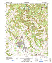
1993 Map of Hardinsburg
USGS Topo · Published 1996About this map
Hardinsburg serves as the focal point of this Breckinridge County landscape, showing the town's structural layout and civic infrastructure in the 1990s. The map detail extends from the central grid to peripheral developments like Codyville and the County Airport, alongside the Fairgrounds and an Athletic Field. The physical geography is defined by a dense network of winding valleys and ridges, most notably Norton Valley and Dorridge. Hydrological features dominate the rural areas, with Sinking Creek and Hardins Creek carving deep paths through the terrain. To the northeast, Clifton Mills sits near the confluence of local waters including Boiling Springs. The presence of numerous unmarked Cemeteries throughout the hills provides valuable points of interest for those researching local family landholdings and rural settlement patterns across the quadrangle.
Find a feature on this map
26 named features on this map. Tap any name to fly to it.
Don’t see what you’re looking for? This feature index may not catch every label — zoom into the map to look around manually.
Map Details
Editions of this 1993 Hardinsburg Map
This is the sole edition of this map. No revisions or reprints were ever made.
Other maps of this area

1928 · Hardinsburg
USGS Topo · 1:48,000

1931 · Hardinsburg
USGS Topo · 1:62,500

1932 · Fordsville
USGS Topo · 1:62,500

1934 · Cannelton
USGS Topo · 1:62,500

1947 · Irvington
USGS Topo · 1:24,000

1947 · Lodiburg
USGS Topo · 1:24,000

1947 · Hardinsburg
USGS Topo · 1:24,000

1947 · Garfield
USGS Topo · 1:24,000

1947 · Hardinsburg
USGS Topo · 1:62,500

1953 · Custer
USGS Topo · 1:24,000