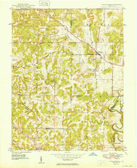
1949 Map of Hardinsburg
USGS Topo · Published 1949About this map
Hardinsburg serves as the central hub of this late 1940s landscape, where the boundary lines of Orange, Washington, Crawford, and Harrison counties converge. The terrain is defined by complex drainage systems, including the Blue River at Horseshoe Bend and the aptly named Whiskey Run. The rural infrastructure of the era is remarkably preserved in this survey, showing a network of small schools such as School No 11 and School No 6 positioned near local crossroads. Significant local landmarks like Railroad Hill and the Baptist Hill Ch offer specific points of interest for those studying the social geography of the region. The map also records early regional transportation routes like the Valeene Pike and Marengo Pike, which connected outlying settlements like Rego and Stoler to the larger town of Marengo.
Find a feature on this map
43 named features on this map. Tap any name to fly to it.
Don’t see what you’re looking for? This feature index may not catch every label — zoom into the map to look around manually.
Map Details
Editions of this 1949 Hardinsburg Map
2 editions found
Other maps of this area

1946 · Depauw
USGS Topo · 1:24,000

1947 · Hardinsburg
USGS Topo · 1:24,000

1948 · Milltown
USGS Topo · 1:24,000

1949 · Hardinsburg
USGS Topo · 1:24,000

1950 · Becks Mill
USGS Topo · 1:24,000

1950 · Valeene
USGS Topo · 1:24,000

1950 · English
USGS Topo · 1:24,000

1953 · Fredericksburg
USGS Topo · 1:24,000

1956 · Vincennes
USGS Topo · 1:250,000

1957 · Vincennes
USGS Topo · 1:250,000