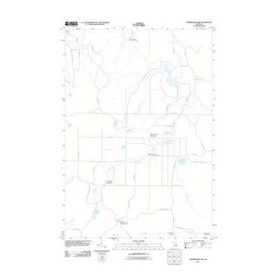
2011 Map of Hardwood Lake
USGS Topo · Published 2011About this map
Pigeon River flows through this heavily forested landscape in Otsego County, defining a region rich in outdoor recreation and conservation. The 2011 survey highlights an extensive network of state forest infrastructure, including the Pigeon River Lookout Tower and multiple specialized campsites such as the Elk Hill Equestrian State Forest Campground and Pine Grove State Forest Campground. The terrain is dotted with a high density of small glacial lakes, from the named Hardwood Lake and Cornwall Lake to the uniquely titled Devils Bowl Lake and Section Four Lake.
Find a feature on this map
57 named features on this map. Tap any name to fly to it.
Don’t see what you’re looking for? This feature index may not catch every label — zoom into the map to look around manually.
Map Details
Editions of this 2011 Hardwood Lake Map
This is the sole edition of this map. No revisions or reprints were ever made.
Other maps of this area

1954 · Gaylord
USGS Topo · 1:62,500

1954 · Hetherton
USGS Topo · 1:62,500

1955 · Cheboygan
USGS Topo · 1:250,000

1957 · Tower
USGS Topo · 1:62,500

1957 · Wolverine
USGS Topo · 1:62,500

1958 · Cheboygan
USGS Topo · 1:250,000

1982 · Petoskey
USGS Topo · 1:100,000

1986 · Silver Lake
USGS Topo · 1:24,000
1986 · Saunders Creek
USGS Topo · 1:24,000
1986 · Tower
USGS Topo · 1:24,000