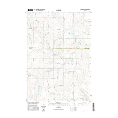
2017 Map of Hardwood Lake
USGS Topo · Published 2017About this map
Pigeon River and Black River define the hydrography of this northern Michigan landscape, where recreation and conservation pathways weave through the timberlands of Otsego and Cheboygan counties. The intersection of the High Country Pathway, Shore to Shore Trail, and Shingle Mill Pathway highlights the area's importance for backcountry travel and outdoor heritage. Distinctive geological and hydrologic features such as the Paul Bunyan Punch Bowl and Devils Bowl Lake provide unique landmarks for local history researchers. The presence of Lansing Club Pond suggests early private sporting interests, while significant water bodies like Hardwood Lake and the Cornwall Creek Flooding area dominate the central and eastern sections, reflecting a landscape shaped by both natural drainage and intentional water management.
Find a feature on this map
64 named features on this map. Tap any name to fly to it.
Don’t see what you’re looking for? This feature index may not catch every label — zoom into the map to look around manually.
Map Details
Editions of this 2017 Hardwood Lake Map
This is the sole edition of this map. No revisions or reprints were ever made.
Other maps of this area

1954 · Gaylord
USGS Topo · 1:62,500

1954 · Hetherton
USGS Topo · 1:62,500

1955 · Cheboygan
USGS Topo · 1:250,000

1957 · Tower
USGS Topo · 1:62,500

1957 · Wolverine
USGS Topo · 1:62,500

1958 · Cheboygan
USGS Topo · 1:250,000

1982 · Petoskey
USGS Topo · 1:100,000

1986 · Silver Lake
USGS Topo · 1:24,000
1986 · Saunders Creek
USGS Topo · 1:24,000
1986 · Tower
USGS Topo · 1:24,000