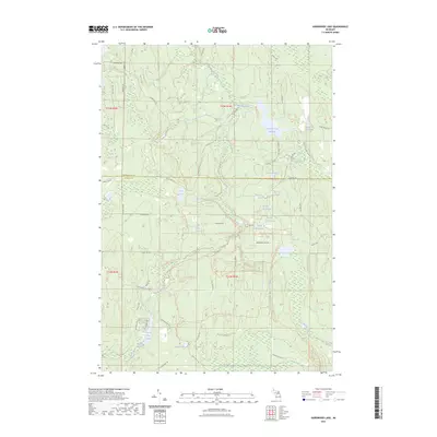
2023 Map of Hardwood Lake
USGS Topo · Published 2023About this map
The Pigeon River and Black River carve through this landscape at the boundary of Cheboygan and Otsego counties. This terrain is defined by its complex hydrography, featuring numerous kettle lakes and wetland areas such as Beaver Marsh and the Lancing Club Pond. The map reveals an extensive network of recreational routes, including the High Country Pathway Trl and the Shore To Shore Trl, which navigate the rises and falls of the glacial topography. A significant man-made hydrologic feature, the Cornwall Creek Flooding, dominates the northern half of the sheet. The presence of the Pigeon River Equestrian Trl and various woodland trails like the Shingle Mill Pathway Trl suggests a region dedicated to conservation and seasonal recreation, where water bodies like Devils Bowl Lake and Section Four Lake remain primary landmarks.
Find a feature on this map
62 named features on this map. Tap any name to fly to it.
Don’t see what you’re looking for? This feature index may not catch every label — zoom into the map to look around manually.
Map Details
Editions of this 2023 Hardwood Lake Map
This is the sole edition of this map. No revisions or reprints were ever made.
Other maps of this area

1954 · Gaylord
USGS Topo · 1:62,500

1954 · Hetherton
USGS Topo · 1:62,500

1955 · Cheboygan
USGS Topo · 1:250,000

1957 · Tower
USGS Topo · 1:62,500

1957 · Wolverine
USGS Topo · 1:62,500

1958 · Cheboygan
USGS Topo · 1:250,000

1982 · Petoskey
USGS Topo · 1:100,000

1986 · Silver Lake
USGS Topo · 1:24,000
1986 · Saunders Creek
USGS Topo · 1:24,000
1986 · Tower
USGS Topo · 1:24,000