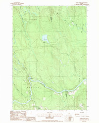
1988 Map of Hardy Pond
USGS Topo · Published 1988About this map
The Piscataquis River carves a deep path through this section of the Maine interior, defining the geography of the small community of Medford. This late-1980s landscape is characterized by a complex network of waterways and wetlands, including the expansive One Thousand Acre Bog and smaller features like Horseshoe Bog and Sweat Bog. These drainage patterns reflect the post-glacial terrain typical of the region, where streams like Scutaze Stream and Schoodic Stream feed into the primary river valley.
Find a feature on this map
28 named features on this map. Tap any name to fly to it.
Don’t see what you’re looking for? This feature index may not catch every label — zoom into the map to look around manually.
Map Details
Editions of this 1988 Hardy Pond Map
This is the sole edition of this map. No revisions or reprints were ever made.
Other maps of this area

1917 · Passadumkeag
USGS Topo · 1:62,500

1933 · Boyd Lake
USGS Topo · 1:62,500

1942 · Lincoln
USGS Topo · 1:62,500

1947 · Schoodic
USGS Topo · 1:62,500

1949 · Schoodic
USGS Topo · 1:62,500

1951 · Boyd Lake
USGS Topo · 1:50,000

1954 · Millinocket
USGS Topo · 1:250,000

1955 · Boyd Lake
USGS Topo · 1:62,500

1957 · Lincoln
USGS Topo · 1:62,500

1958 · Millinocket
USGS Topo · 1:250,000