Loading...
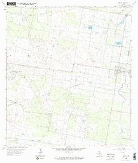
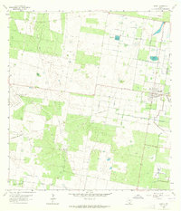
Loading map...1963 Map of Hargill
USGS Topo · Published 1965This historical map portrays the area of Hargill in 1963, primarily covering Hidalgo County as well as portions of Willacy County. Featuring a scale of 1:24000, this map provides a highly detailed snapshot of the terrain, roads, buildings, counties, and historical landmarks in the Hargill region at the time. Published in 1965, it is one of 2 known editions of this map due to revisions or reprints.
Map Details
Date Portrayed1963
Date Published1965
PublisherU.S. Geological Survey
Map TypeTopographic
Scale1:24000
Physical Dimensions22.7 x 26.8 inches
Editions of this 1963 Hargill Map
2 editions found
Historical Maps of Willacy County Through Time
1 maps found
Featured Locations
- Edinburg, TX
- Edinburg Acres Colonia, TX
- Harding Gill Tract Colonia, TX
- Ingle-Doolittle Colonia, TX
- La Coma Heights Colonia, TX
Source Details
SourceU.S. Geological Survey
CopyrightPublic Domain