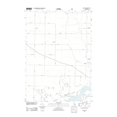
2012 Map of Harlan
USGS Topo · Published 2012About this map
Harlan and Bagnall anchor this northern Michigan landscape in Cleon Township, where the road network follows a rigid grid interrupted by the winding waters of Fletcher Creek and First Creek. For genealogists and local historians, several small burial grounds are identified across the township, including the Harlan Cemetery, the Crowell Family Cemetery, and Minor Cemetery. The southern portion of the map is defined by the larger waters of the Hodenpyl Dam Pond, where the terrain transitions into more recreation-focused areas like Mesick RV Park and the low-lying Sneaky Valley. This 2012 survey illustrates how modern development and seasonal recreation coexist with older settlement patterns and long-standing family landholdings in Manistee County.
Find a feature on this map
59 named features on this map. Tap any name to fly to it.
Don’t see what you’re looking for? This feature index may not catch every label — zoom into the map to look around manually.
Map Details
Editions of this 2012 Harlan Map
This is the sole edition of this map. No revisions or reprints were ever made.
Other maps of this area

1954 · Traverse City
USGS Topo · 1:250,000

1956 · Kingsley
USGS Topo · 1:62,500

1956 · Mesick
USGS Topo · 1:62,500

1956 · Thompsonville
USGS Topo · 1:62,500

1957 · Copemish
USGS Topo · 1:62,500

1958 · Traverse City
USGS Topo · 1:250,000
1976 · Thompsonville SW
USGS Topo · 1:24,000

1976 · Thompsonville SE
USGS Topo · 1:24,000

1983 · Cadillac
USGS Topo · 1:100,000
1983 · Thompsonville
USGS Topo · 1:25,000