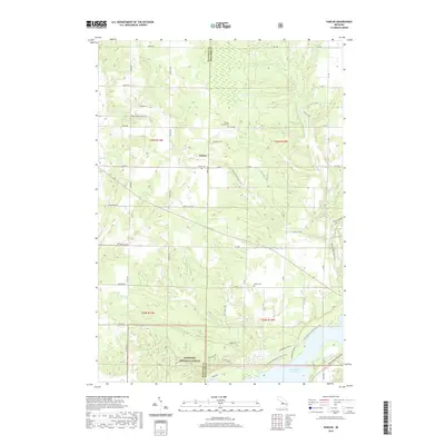
2019 Map of Harlan
USGS Topo · Published 2019About this map
Harlan serves as the central hub of this northern Michigan landscape, situated at the boundary of Manistee and Wexford Counties. This area reflects a quiet rural transition, where the Manistee National Forest meets private farm holdings and the remnants of regional rail infrastructure. The Betsie Valley State Trail cuts through the terrain, repurposing historical corridors for modern use. To the south, the waters of Hodenpyl Dam Pond and Cripple Cr define the hydrological character of the basin. For genealogists and local historians, several small burial sites are preserved here, including the Harlan Cem, Minor Cem, and the Crowell Family Cem, offering specific points of interest for family researchers tracing the lineage of Cleon Township and the surrounding timber and agricultural lands.
Find a feature on this map
58 named features on this map. Tap any name to fly to it.
Don’t see what you’re looking for? This feature index may not catch every label — zoom into the map to look around manually.
Map Details
Editions of this 2019 Harlan Map
This is the sole edition of this map. No revisions or reprints were ever made.
Other maps of this area

1954 · Traverse City
USGS Topo · 1:250,000

1956 · Kingsley
USGS Topo · 1:62,500

1956 · Mesick
USGS Topo · 1:62,500

1956 · Thompsonville
USGS Topo · 1:62,500

1957 · Copemish
USGS Topo · 1:62,500

1958 · Traverse City
USGS Topo · 1:250,000
1976 · Thompsonville SW
USGS Topo · 1:24,000

1976 · Thompsonville SE
USGS Topo · 1:24,000

1983 · Cadillac
USGS Topo · 1:100,000
1983 · Thompsonville
USGS Topo · 1:25,000