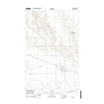
2014 Map of Harlem
USGS Topo · Published 2014About this map
Harlem sits as the central hub of this northern Montana landscape, where the town's grid is bounded by the irrigation infrastructure of the Harlem Canal and the meandering Milk River. The map details a community defined by its water management and agricultural reach, from the Thirtymile Reservoir in the east to the extensive reach of the Harlem Canal that parallels the river valley. To the north, the North Harlem Colony represents a distinct communal settlement pattern, situated near the headwaters of Thirtymile Cr and Borders Coulee. The local transport network is anchored by Old US 2 and the Harlem Airport, which support the regional movement of goods and people across the high plains. Researchers will find precise locations for local landmarks like the Harlem Cem, providing a detailed view of the settlement's footprint in the early 21st century.
Find a feature on this map
31 named features on this map. Tap any name to fly to it.
Don’t see what you’re looking for? This feature index may not catch every label — zoom into the map to look around manually.
Map Details
Editions of this 2014 Harlem Map
This is the sole edition of this map. No revisions or reprints were ever made.
Other maps of this area

1903 · Wayne Creek
USGS Topo · 1:62,500

1905 · Wayne Creek
USGS Topo · 1:62,500

1905 · Harlem
USGS Topo · 1:62,500

1913 · Cherry Ridge
USGS Topo · 1:125,000

1953 · Havre
USGS Topo · 1:250,000

1957 · Havre
USGS Topo · 1:250,000

1958 · Havre
USGS Topo · 1:250,000

1964 · Threemile Reservoir
USGS Topo · 1:24,000
1964 · Fort Belknap Agency
USGS Topo · 1:24,000
1964 · Big Coulee
USGS Topo · 1:24,000