
1959 Map of Harney
USGS Topo · Published 1961About this map
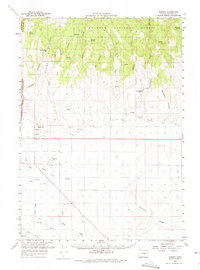
Malheur National Forest dominates the northern reaches of this High Desert landscape, where the terrain breaks into sharp ridges and canyons like Devine Canyon and Prater Canyon. In the late 1950s, the transition from the timbered uplands to the southern plains is marked by a complex system of water management and transit. The Hanley Canal and various sloughs, including Foley Slough and Poison Creek, crisscross the lower elevations near the settlement of Harney.
Find a feature on this map
42 named features on this map. Tap any name to fly to it.
Don’t see what you’re looking for? This feature index may not catch every label — zoom into the map to look around manually.
Map Details
Editions of this 1959 Harney Map
2 editions found
Other maps of this area

1955 · Burns
USGS Topo · 1:250,000

1958 · Burns
USGS Topo · 1:250,000

1959 · Burns
USGS Topo · 1:250,000

1959 · West Myrtle Butte
USGS Topo · 1:62,500

1959 · Dog Mountain
USGS Topo · 1:62,500

1959 · Lawen
USGS Topo · 1:62,500

1960 · Crane
USGS Topo · 1:62,500

1960 · Burns
USGS Topo · 1:62,500

1960 · Burns
USGS Topo · 1:24,000

1961 · Calamity Butte
USGS Topo · 1:62,500