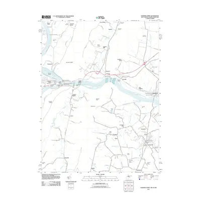
2011 Map of Harpers Ferry
USGS Topo · Published 2011About this map
Harpers Ferry sits at the dramatic confluence of the Potomac River and Shenandoah River, a landscape defined by steep gaps and strategic transport corridors. The map highlights the legacy of 19th-century infrastructure, following the Chesapeake and Ohio Canal as it skirts the northern bank and tracing the path of the Baltimore and Ohio Railroad Covered Bridge crossing into the Lower Town. On the Maryland side, industrial sites like Dargan Quarry and Garretts Mill represent the local manufacturing and resource history, while the Virginia and West Virginia hills are dotted with family-named landmarks like Roelkeys Knoll and Loudoun Heights.
Find a feature on this map
140 named features on this map. Tap any name to fly to it.
Don’t see what you’re looking for? This feature index may not catch every label — zoom into the map to look around manually.
Map Details
Editions of this 2011 Harpers Ferry Map
This is the sole edition of this map. No revisions or reprints were ever made.
Other maps of this area

1884 · Harpers Ferry
USGS Topo · 1:125,000

1891 · Harpers Ferry
USGS Topo · 1:125,000

1893 · Harpers Ferry
USGS Topo · 1:125,000

1908 · Middletown
USGS Topo · 1:48,000

1910 · Antietam
USGS Topo · 1:62,500

1914 · Martinsburg
USGS Topo · 1:48,000

1916 · Martinsburg
USGS Topo · 1:62,500

1916 · Berryville
USGS Topo · 1:62,500

1939 · Berryville
USGS Topo · 1:48,000
1944 · Waterford
USGS Topo · 1:31,680