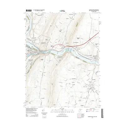
2014 Map of Harpers Ferry
USGS Topo · Published 2014About this map
Harpers Ferry sits at the confluence of the Potomac River and Shenandoah River, where West Virginia, Maryland, and Virginia meet. This survey shows the region's complex geography of mountain ridges like Elk Ridge and Loudoun Heights that flank the river gap. In the Maryland section, the Chesapeake and Ohio Canal parallels the river, passing through Sandy Hook, Weverton, and the railroad hub of Brunswick. The landscape is dotted with small agricultural settlements and historic sites, including Garretts Mill and Knoxville. To the south in Virginia, Lovettsville anchors a region characterized by family-named cemeteries such as the African Methodist Episcopal Cem and Saint James Cem. The map provides detailed locations for landmarks within the Harpers Ferry National Historical Park, including Jefferson Rock and the Baltimore and Ohio Railroad Covered Bridge.
Find a feature on this map
92 named features on this map. Tap any name to fly to it.
Don’t see what you’re looking for? This feature index may not catch every label — zoom into the map to look around manually.
Map Details
Editions of this 2014 Harpers Ferry Map
This is the sole edition of this map. No revisions or reprints were ever made.
Other maps of this area

1884 · Harpers Ferry
USGS Topo · 1:125,000

1891 · Harpers Ferry
USGS Topo · 1:125,000

1893 · Harpers Ferry
USGS Topo · 1:125,000

1908 · Middletown
USGS Topo · 1:48,000

1910 · Antietam
USGS Topo · 1:62,500

1914 · Martinsburg
USGS Topo · 1:48,000

1916 · Martinsburg
USGS Topo · 1:62,500

1916 · Berryville
USGS Topo · 1:62,500

1939 · Berryville
USGS Topo · 1:48,000
1944 · Waterford
USGS Topo · 1:31,680