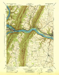
1944 Map of Harpers Ferry
USGS Topo · Published 1944About this map
Harpers Ferry stands at the dramatic confluence of the Potomac River and Shenandoah River, a site defined by the deep water gaps cut through Elk Ridge and South Mountain. During this mid-1940s survey, the regional transportation network is prominently displayed, showing the Baltimore and Ohio Railroad following the riverbanks while the Chesapeake and Ohio Canal (Abandoned) remains a visible trace of an earlier era. The map details a landscape of ridge-top heights and fertile valleys, from the industrial activity in Brunswick to the scattered agrarian settlements like Lovettsville and Yarrowsburg. Genealogists will find significant value in the detailed plotting of local institutions, including Stoker College and numerous rural houses of worship such as St Pauls Church and Ebenezer Church. Family-named landmarks like Garretts Mill and Georges Mill further anchor the geography to the area's local history.
Find a feature on this map
44 named features on this map. Tap any name to fly to it.
Don’t see what you’re looking for? This feature index may not catch every label — zoom into the map to look around manually.
Map Details
Editions of this 1944 Harpers Ferry Map
This is the sole edition of this map. No revisions or reprints were ever made.
Other maps of this area

1884 · Harpers Ferry
USGS Topo · 1:125,000

1891 · Harpers Ferry
USGS Topo · 1:125,000

1893 · Harpers Ferry
USGS Topo · 1:125,000

1908 · Middletown
USGS Topo · 1:48,000

1910 · Antietam
USGS Topo · 1:62,500

1914 · Martinsburg
USGS Topo · 1:48,000

1916 · Martinsburg
USGS Topo · 1:62,500

1916 · Berryville
USGS Topo · 1:62,500

1939 · Berryville
USGS Topo · 1:48,000
1944 · Waterford
USGS Topo · 1:31,680