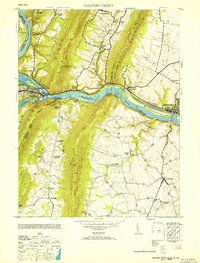
1953 Map of Harpers Ferry
USGS Topo · Published 1953About this map
The Potomac River and Shenandoah River converge at a historic tri-state intersection where Maryland, West Virginia, and Virginia meet. This mid-century survey captures the industrial and educational landscape of Harpers Ferry, including the campus of Storer College and the strategic rail infrastructure of the Baltimore and Ohio railroad. The topography is dominated by the steep ridges of Elk Ridge and South Mountain, which channel the river through narrow gaps that have historically dictated transportation routes.
Find a feature on this map
50 named features on this map. Tap any name to fly to it.
Don’t see what you’re looking for? This feature index may not catch every label — zoom into the map to look around manually.
Map Details
Editions of this 1953 Harpers Ferry Map
This is the sole edition of this map. No revisions or reprints were ever made.
Other maps of this area

1884 · Harpers Ferry
USGS Topo · 1:125,000

1891 · Harpers Ferry
USGS Topo · 1:125,000

1893 · Harpers Ferry
USGS Topo · 1:125,000

1908 · Middletown
USGS Topo · 1:48,000

1910 · Antietam
USGS Topo · 1:62,500

1914 · Martinsburg
USGS Topo · 1:48,000

1916 · Martinsburg
USGS Topo · 1:62,500

1916 · Berryville
USGS Topo · 1:62,500

1939 · Berryville
USGS Topo · 1:48,000
1944 · Waterford
USGS Topo · 1:31,680