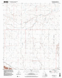
1998 Map of Harpers Well
USGS Topo · Published 2003About this map
Harpers Well stands as a focal point in this arid desert landscape, where water sources like San Felipe Creek and various seasonal washes dictate the terrain's character. The 1998 data reveals a region defined by its extreme topography, from the expansive Lower Borrego Valley to the prominent Superstition Hills and West Mesa. Notable infrastructure includes the Mining Railway cutting through the southwestern corner near Fish Creek, and the presence of the US Naval Air Facility along the eastern boundary. The network of unpaved routes, such as Old Kane Spring Road and numerous 4WD tracks, underscores the area's isolation and its historical reliance on specific transit corridors. This survey provides a precise view of the Imperial Valley's northwestern reaches before significant modern shifts, capturing specific benchmarks like BM 24 and BM 59 across the sea-level flats.
Find a feature on this map
24 named features on this map. Tap any name to fly to it.
Don’t see what you’re looking for? This feature index may not catch every label — zoom into the map to look around manually.
Map Details
Editions of this 1998 Harpers Well Map
This is the sole edition of this map. No revisions or reprints were ever made.
Other maps of this area

1915 · El Centro
USGS Topo · 1:125,000

1931 · Vallecito
USGS Topo · 1:125,000

1931 · Carrizo
USGS Topo · 1:125,000

1940 · Kane Spring
USGS Topo · 1:62,500

1940 · Plaster City
USGS Topo · 1:62,500

1942 · Barrel Spring
USGS Topo · 1:62,500

1942 · El Centro
USGS Topo · 1:250,000

1942 · Carrizo Mtn
USGS Topo · 1:62,500

1943 · Vallecito
USGS Topo · 1:125,000

1944 · Plaster City
USGS Topo · 1:62,500