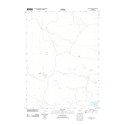
2011 Map of Harr Valley
USGS Topo · Published 2011About this map
Morris Ranch serves as the primary landmark in this expanse of the Nebraska Sandhills, situated in the northwestern corner of the quadrangle. The landscape is defined by its characteristic depressions and valleys, notably Remalia Valley and Harr Valley, which represent the unique topography of this ranching region. The hydrological patterns of the area are marked by numerous small, seasonal ponds and wetlands, culminating in the more permanent Moon Lake in the southeast corner. The network of light-duty and unimproved roads reveals a sparsely populated terrain where land use is dictated by the natural drainages and grazing land. This 2011 survey captures the area before modern developments significantly altered the traditional ranching footprint of Cherry County.
Find a feature on this map
4 named features on this map. Tap any name to fly to it.
Don’t see what you’re looking for? This feature index may not catch every label — zoom into the map to look around manually.
Map Details
Editions of this 2011 Harr Valley Map
This is the sole edition of this map. No revisions or reprints were ever made.
Other maps of this area

1949 · Long Lake
USGS Topo · 1:62,500

1950 · Wood Lake
USGS Topo · 1:62,500

1950 · Arabia
USGS Topo · 1:62,500

1951 · Long Lake
USGS Topo · 1:62,500

1951 · Moon Lake
USGS Topo · 1:62,500

1957 · Valentine
USGS Topo · 1:250,000

1959 · Valentine
USGS Topo · 1:250,000

1985 · Wilson Valley
USGS Topo · 1:24,000
1985 · Brush Creek
USGS Topo · 1:24,000
1985 · Arabia SE
USGS Topo · 1:24,000