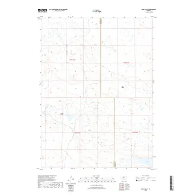
2017 Map of Harr Valley
USGS Topo · Published 2017About this map
Harr Valley and Remalia Valley form the center of this 2017 study of the Nebraska Sandhills, a landscape defined by an intricate network of wetlands and seasonal water bodies. The geography here is characterized by a sparse human footprint, with Hill Rd serving as one of the few named navigational routes through the undulating terrain of eastern Cherry County. In the southeastern corner, Moon Lake provides a significant hydrological anchor in a region dominated by township divisions such as t29n r25w and t28n r24w. The map illustrates the specialized ranching and conservation environment of the High Plains, where the concentration of wetlands between the dunes highlights the unique drainage patterns of the area.
Find a feature on this map
9 named features on this map. Tap any name to fly to it.
Don’t see what you’re looking for? This feature index may not catch every label — zoom into the map to look around manually.
Map Details
Editions of this 2017 Harr Valley Map
This is the sole edition of this map. No revisions or reprints were ever made.
Other maps of this area

1949 · Long Lake
USGS Topo · 1:62,500

1950 · Wood Lake
USGS Topo · 1:62,500

1950 · Arabia
USGS Topo · 1:62,500

1951 · Long Lake
USGS Topo · 1:62,500

1951 · Moon Lake
USGS Topo · 1:62,500

1957 · Valentine
USGS Topo · 1:250,000

1959 · Valentine
USGS Topo · 1:250,000

1985 · Wilson Valley
USGS Topo · 1:24,000
1985 · Brush Creek
USGS Topo · 1:24,000
1985 · Arabia SE
USGS Topo · 1:24,000