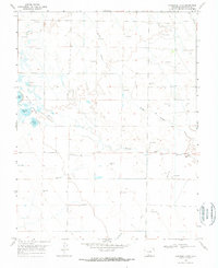
1968 Map of Harrence Lake
USGS Topo · Published 1970About this map
Hydrological management defines this high-elevation landscape in Saguache County, where a complex system of flowing wells and arroyos supports the local ecosystem. The map reveals the intricate water network of the Russell Lakes region, including Harrence Lake, Davey Lake, and Island Lake. A Fish Hatchery located near the western margin suggests the importance of wildlife and aquatic resource management in the late 1960s. The terrain is characterized by its drainage patterns, with Werner Arroyo and Bull Arroyo feeding into larger systems like Russell Creek and La Garita Creek. Numerous Flowing Wells are plotted across the township and range lines, indicating the subsurface water reliance that sustained this portion of the San Luis Valley during the mid-20th century.
Find a feature on this map
14 named features on this map. Tap any name to fly to it.
Don’t see what you’re looking for? This feature index may not catch every label — zoom into the map to look around manually.
Map Details
Editions of this 1968 Harrence Lake Map
2 editions found
Other maps of this area

1915 · Del Norte
USGS Topo · 1:125,000

1917 · Del Norte
USGS Topo · 1:125,000

1945 · Durango
USGS Topo · 1:250,000

1953 · Durango
USGS Topo · 1:250,000

1954 · Durango
USGS Topo · 1:250,000

1954 · Trinidad
USGS Topo · 1:250,000

1954 · Pueblo
USGS Topo · 1:250,000

1955 · Trinidad
USGS Topo · 1:250,000

1956 · Montrose
USGS Topo · 1:250,000

1957 · Pueblo
USGS Topo · 1:250,000