
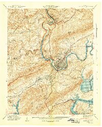
1941 Map of Harriman
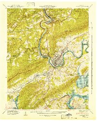
USGS Topo · Published 1952About this map
The confluence of the Clinch River and the Emory River serves as the focal point for this industrial and transport corridor in Roane and Morgan counties. The landscape is defined by the massive ridges of the Cumberland Plateau and Walden Ridge, where the newly formed Watts Bar Reservoir begins to back up into the local river valleys. As a vital rail hub, the area features the intersection of the Southern Railway, Louisville and Nashville Railroad, and the Tennessee Central Railway, supporting the growth of Harriman and South Harriman. Genealogists will find numerous family landmarks, from Willard Park Cem and Fry Cem to several local schools like Rankin Sch and Cardiff Sch. The presence of CCC Camp No 27 near Kingston and an Airway Beacon on the ridge reflects the early 1940s infrastructure and government investment in the region.
Find a feature on this map
90 named features on this map. Tap any name to fly to it.
Don’t see what you’re looking for? This feature index may not catch every label — zoom into the map to look around manually.
Map Details
Editions of this 1941 Harriman Map
3 editions found
Other maps of this area

1887 · Kingston
USGS Topo · 1:125,000

1891 · Kingston
USGS Topo · 1:125,000

1893 · Briceville
USGS Topo · 1:125,000

1893 · Kingston
USGS Topo · 1:125,000

1895 · Wartburg
USGS Topo · 1:125,000

1895 · Loudon
USGS Topo · 1:125,000

1895 · Briceville
USGS Topo · 1:125,000

1896 · Wartburg
USGS Topo · 1:125,000

1896 · Briceville
USGS Topo · 1:125,000

1935 · Rockwood
USGS Topo · 1:24,000