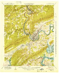
1941 Map of Harriman
USGS Topo · Published 1941About this map
Harriman serves as a critical rail hub at the intersection of the Southern, Tennessee Central, and Louisville and Nashville lines. This 1941 survey documents the town and surrounding Roane County landscape just as the Watts Bar Reservoir was being established, with the Emory River and Clinch River forming the primary drainage through the gaps of Walden Ridge.
Find a feature on this map
73 named features on this map. Tap any name to fly to it.
Don’t see what you’re looking for? This feature index may not catch every label — zoom into the map to look around manually.
Map Details
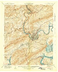
Editions of this 1941 Harriman Map
3 editions found

Other maps of this area

1887 · Kingston
USGS Topo · 1:125,000

1891 · Kingston
USGS Topo · 1:125,000

1893 · Briceville
USGS Topo · 1:125,000

1893 · Kingston
USGS Topo · 1:125,000

1895 · Wartburg
USGS Topo · 1:125,000

1895 · Loudon
USGS Topo · 1:125,000

1895 · Briceville
USGS Topo · 1:125,000

1896 · Wartburg
USGS Topo · 1:125,000

1896 · Briceville
USGS Topo · 1:125,000

1935 · Rockwood
USGS Topo · 1:24,000