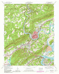
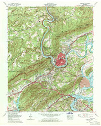
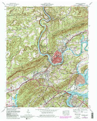
1968 Map of Harriman
USGS Topo · Published 1980About this map
The Emory River snakes through the dramatic topography of the Cumberland Plateau and Walden Ridge, defining the industrial and transport corridor of Roane County. The city of Harriman serves as the central hub, where the Southern Railway and Louisville and Nashville Railroad converge at Harriman Junction. This period of the late 1960s captures the landscape just as Interstate 40 was reshaping regional travel, cutting across the southern half of the map near Midtown.
Find a feature on this map
113 named features on this map. Tap any name to fly to it.
Don’t see what you’re looking for? This feature index may not catch every label — zoom into the map to look around manually.
Map Details
Editions of this 1968 Harriman Map
3 editions found
Other maps of this area

1887 · Kingston
USGS Topo · 1:125,000

1891 · Kingston
USGS Topo · 1:125,000

1893 · Briceville
USGS Topo · 1:125,000

1893 · Kingston
USGS Topo · 1:125,000

1895 · Wartburg
USGS Topo · 1:125,000

1895 · Loudon
USGS Topo · 1:125,000

1895 · Briceville
USGS Topo · 1:125,000

1896 · Wartburg
USGS Topo · 1:125,000

1896 · Briceville
USGS Topo · 1:125,000

1935 · Rockwood
USGS Topo · 1:24,000