1968 Map of Harriman
USGS Topo · Published 1980About this map
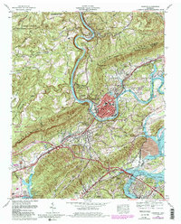
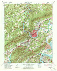
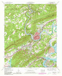
The Emory River serves as the central artery of this region, winding through the complex terrain of Walden Ridge and Edd Ridge. At its confluence with the Clinch River, the landscape opens into the broad expanse of Watts Bar Lake. This survey illustrates the industrial and strategic importance of the area during the late 1960s, featuring the massive Kingston Steam Plant and the Tennessee National Guard Armory. Transportation infrastructure is particularly dense here, with the Southern Railway and Tennessee Central RR converging near the city of Harriman.
Find a feature on this map
64 named features on this map. Tap any name to fly to it.
Don’t see what you’re looking for? This feature index may not catch every label — zoom into the map to look around manually.
Map Details
Editions of this 1968 Harriman Map
3 editions found
Other maps of this area

1887 · Kingston
USGS Topo · 1:125,000

1891 · Kingston
USGS Topo · 1:125,000

1893 · Briceville
USGS Topo · 1:125,000

1893 · Kingston
USGS Topo · 1:125,000

1895 · Wartburg
USGS Topo · 1:125,000

1895 · Loudon
USGS Topo · 1:125,000

1895 · Briceville
USGS Topo · 1:125,000

1896 · Wartburg
USGS Topo · 1:125,000

1896 · Briceville
USGS Topo · 1:125,000

1935 · Rockwood
USGS Topo · 1:24,000