1952 Map of Harriman
USGS Topo · Published 1954About this map
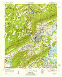
The Emory River snakes through the heart of this 1950s Tennessee landscape, defining the industrial and civic development of Harriman and Kingston. This survey illustrates the area shortly after the Tennessee Valley Authority’s mid-century expansion, capturing the vast reach of Watts Bar Lake and the prominent Kingston Steam Plant near the confluence with the Clinch River. The topographical contrast is sharp between the ridgelines of Walden Ridge and the developing infrastructure of South Harriman.
Find a feature on this map
70 named features on this map. Tap any name to fly to it.
Don’t see what you’re looking for? This feature index may not catch every label — zoom into the map to look around manually.
Map Details
Editions of this 1952 Harriman Map
This is the sole edition of this map. No revisions or reprints were ever made.
Other maps of this area

1887 · Kingston
USGS Topo · 1:125,000

1891 · Kingston
USGS Topo · 1:125,000

1893 · Briceville
USGS Topo · 1:125,000

1893 · Kingston
USGS Topo · 1:125,000

1895 · Wartburg
USGS Topo · 1:125,000

1895 · Loudon
USGS Topo · 1:125,000

1895 · Briceville
USGS Topo · 1:125,000

1896 · Wartburg
USGS Topo · 1:125,000

1896 · Briceville
USGS Topo · 1:125,000

1935 · Rockwood
USGS Topo · 1:24,000