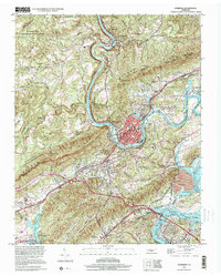
1998 Map of Harriman
USGS Topo · Published 2001About this map
Harriman sits at the base of Walden Ridge, where the Emory River cuts through the high ground before merging with the Clinch River at Watts Bar Lake. This late-twentieth-century survey illustrates the industrial and transit infrastructure of Roane and Morgan counties, including the massive Kingston Steam Plant and the heavy rail lines of the Southern Railway. The terrain is characterized by steep ridges like Ebb Ridge and Grassy Ridge, which hem in settlements like Oakdale and South Harriman.
Find a feature on this map
67 named features on this map. Tap any name to fly to it.
Don’t see what you’re looking for? This feature index may not catch every label — zoom into the map to look around manually.
Map Details
Editions of this 1998 Harriman Map
This is the sole edition of this map. No revisions or reprints were ever made.
Other maps of this area

1887 · Kingston
USGS Topo · 1:125,000

1891 · Kingston
USGS Topo · 1:125,000

1893 · Briceville
USGS Topo · 1:125,000

1893 · Kingston
USGS Topo · 1:125,000

1895 · Wartburg
USGS Topo · 1:125,000

1895 · Loudon
USGS Topo · 1:125,000

1895 · Briceville
USGS Topo · 1:125,000

1896 · Wartburg
USGS Topo · 1:125,000

1896 · Briceville
USGS Topo · 1:125,000

1935 · Rockwood
USGS Topo · 1:24,000