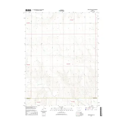
2015 Map of Harris Draw NE
USGS Topo · Published 2015About this map
The N Fork Smoky Hill River carves through the southern sections of this Wallace County landscape, defining the topography alongside Sand Cr. This 2015 survey reveals the sparse, grid-based development of the high plains, where the Sherman Co and Wallace Co line marks a significant administrative boundary. Family history is anchored by the Hartzler Cem, a solitary landmark near the center of the sheet that speaks to the area's agricultural settlement. The map is dominated by a systematic network of county roads, including Co Rd 57 and Co Rd 25, which facilitate movement across the large township and range blocks. The terrain is characterized by the drainage patterns feeding into the river, illustrating the essential relationship between water sources and land division in western Kansas.
Find a feature on this map
19 named features on this map. Tap any name to fly to it.
Don’t see what you’re looking for? This feature index may not catch every label — zoom into the map to look around manually.
Map Details
Editions of this 2015 Harris Draw NE Map
This is the sole edition of this map. No revisions or reprints were ever made.
Other maps of this area

1954 · Goodland
USGS Topo · 1:250,000

1956 · Goodland
USGS Topo · 1:250,000

1957 · Goodland
USGS Topo · 1:250,000

1959 · Harris Draw
USGS Topo · 1:62,500

1966 · Goodland
USGS Topo · 1:24,000

1966 · Edson
USGS Topo · 1:24,000

1966 · Brewster
USGS Topo · 1:24,000

1969 · Mc Allaster NW
USGS Topo · 1:24,000
1969 · Mc Allaster
USGS Topo · 1:24,000
1979 · Harris Draw NE
USGS Topo · 1:24,000