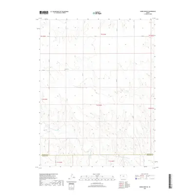
2018 Map of Harris Draw NE
USGS Topo · Published 2018About this map
The N Fork Smoky Hill River flows through the southern reaches of this High Plains landscape, marking the transition between Sherman and Wallace counties. This 2018 survey reveals a sparse, high-elevation prairie environment defined more by its drainage patterns and section lines than by dense settlement. The most significant historical marker is the Hartzler Cem, located north of Sand Cr and accessed via Co RD 55. This site provides a focal point for genealogical research in an otherwise open range. The map illustrates a strictly grid-based transportation network, with arterial routes like Co Rd 25 and Co Rd 57 providing access across the township lines of T9S through T11S. The rugged drainage of the river valley contrasts sharply with the flat upland plateaus, showing how local topography influenced the placement of rural roads and homestead boundaries.
Find a feature on this map
21 named features on this map. Tap any name to fly to it.
Don’t see what you’re looking for? This feature index may not catch every label — zoom into the map to look around manually.
Map Details
Editions of this 2018 Harris Draw NE Map
This is the sole edition of this map. No revisions or reprints were ever made.
Other maps of this area

1954 · Goodland
USGS Topo · 1:250,000

1956 · Goodland
USGS Topo · 1:250,000

1957 · Goodland
USGS Topo · 1:250,000

1959 · Harris Draw
USGS Topo · 1:62,500

1966 · Goodland
USGS Topo · 1:24,000

1966 · Edson
USGS Topo · 1:24,000

1966 · Brewster
USGS Topo · 1:24,000

1969 · Mc Allaster NW
USGS Topo · 1:24,000
1969 · Mc Allaster
USGS Topo · 1:24,000
1979 · Harris Draw NE
USGS Topo · 1:24,000