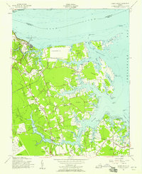
1955 Map of Harris Grove
USGS Topo · Published 1958About this map
Colonial National Historical Park Yorktown Battlefield anchors the northwestern corner of this coastal survey, where the historic Moore House stands near the York River. The landscape is defined by the intricate peninsulas of Goodwin Neck, Crab Neck, and Fish Neck, separated by tidal inlets like Chisman Creek and Back Creek. These necks of land were centers of maritime and agricultural life in the mid-1950s, dotted with small communities and family-named landmarks.
Find a feature on this map
75 named features on this map. Tap any name to fly to it.
Don’t see what you’re looking for? This feature index may not catch every label — zoom into the map to look around manually.
Map Details
Editions of this 1955 Harris Grove Map
This is the sole edition of this map. No revisions or reprints were ever made.
Other maps of this area

1906 · Williamsburg
USGS Topo · 1:62,500

1907 · Yorktown
USGS Topo · 1:62,500

1907 · Hampton
USGS Topo · 1:62,500

1916 · Mathews
USGS Topo · 1:62,500

1917 · Mathews
USGS Topo · 1:62,500

1943 · Yorktown
USGS Topo · 1:62,500

1943 · Richmond
USGS Topo · 1:250,000

1944 · Hampton
USGS Topo · 1:24,000

1944 · Yorktown
USGS Topo · 1:24,000

1944 · Messick
USGS Topo · 1:24,000