Old Maps of York County, Virginia
Explore 76 old maps of York County, spanning from 1906 to today. These high-resolution historic maps reveal how streets, neighborhoods, landmarks, and natural features evolved over time — perfect for genealogy, metal detecting, research, and local history exploration.
What you can do with these maps:
- See how York County changed over time: Compare historical maps to modern-day views to trace roads, homesites, rail lines & more.
- View detailed metadata: Each map includes creators, publishers, year, scale, and archive source.
- Overlay maps with satellite & LiDAR: Visualize the past alongside modern tools to explore terrain & human change.
- Trusted historical sources: Maps sourced from the USGS, Library of Congress, and other archives.
- Access maps your way: View online, download high-res files, or order prints for personal or research use.
Start exploring old maps of York County to uncover forgotten places, hidden landmarks, and the deep history beneath your feet.
York County, VA maps
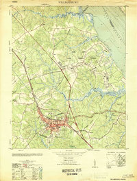
(76)- 1906 Map of Williamsburg
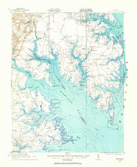
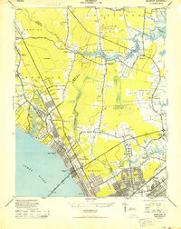
 1906 Williamsburg1906 Print · USGSCoastal Virginia at the turn of the century reveals a landscape of river steamboats and early rail lines near the York River. Researchers can trace historic church sites like Abingdon Church, colonial-era Powhatans House Ruins, and the infrastructure of Bigler Mill.6 unique versions available
 - 1907 Map of Yorktown
 1907 Yorktown1907 Print · USGSThe Virginia Peninsula and the banks of the James River are shown here at the turn of the century, revealing a landscape defined by colonial roots and Civil War defenses. Genealogists can trace early twentieth-century life at Denbigh P O, Bacons Castle, and the National Cem.6 unique versions available
 - 1907 Map of Hampton, 1916 Print
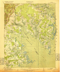
 1907 Hampton1916 Print · USGSThe Virginia Peninsula is mapped here in the early twentieth century, showing a coastal landscape shaped by its military and maritime heritage. Genealogists can trace family lines in settlements like Poquoson, Dare, and Phoebus, or locate records at the National Soldiers Home and Hampton Normal School.6 unique versions available
 - 1916 Map of Mathews, 1965 Print
 1916 Mathews1965 Print · USGSThe Virginia Middle Peninsula during the mid-1910s reveals a maritime landscape where travel centered on the water. Genealogists can trace family roots through numerous local landmarks like Lee-Jackson School, Trinity Church, and the remains of Fort Nonsense.
 - 1917 Map of Mathews
 1917 Mathews1917 Print · USGSThe Virginia Tidewater is captured here during the First World War, showing a coastal world reliant on the Mobjack Bay and the York River. Researchers can trace old steamboat routes and locate vanished community landmarks like Fort Nonsense (Ruins) and the Lee-Jackson School.7 unique versions available
 - 1917 Map of Toano, 1959 Print
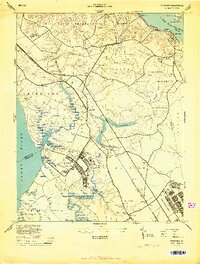
 1917 Toano1959 Print · USGSCoastal Virginia during the early twentieth century shows a landscape where rail lines and steamboat routes intersect. Genealogists can trace family roots through numerous sites like Hickory Neck Church, One Eye School, and Barrets Ferry.
 - 1918 Map of Toano
 1918 Toano1918 Print · USGSThe Virginia Peninsula comes alive in the years following the Great War, showing a landscape of river landings and rail-side villages. Researchers can trace the path of the Chesapeake and Ohio through Toano or locate early rural schoolhouses like One Eye School and Brickbat School.3 unique versions available
 - 1943 Map of Yorktown
 1943 Yorktown1943 Print · USGSThe Virginia Tidewater is captured here during the Second World War, showing the strategic riverfronts of the James and Warwick rivers. Researchers can locate colonial landmarks and defensive ruins like Old Fort Yorktown, Bacons Castle, and Warwick Courthouse.
 - 1943 Map of Richmond, 1972 Print
 1943 Richmond1972 Print · USGSCoastal Virginia and the state capital are shown in detail during the mid-century era of infrastructure expansion. Genealogists and historians can trace the grounds of Richmond Nat Battlefield Park, locate the Yorktown Nat Cem, or follow the many rural routes through Amelia Court House and Tappahannock.
 - 1944 Map of Yorktown
 1944 Yorktown1944 Print · USGSVirginia's historic Peninsula is captured here during the height of the 1940s mobilization, showing the massive infrastructure of wartime military installations. Researchers can trace the grounds of Fort Eustis and Camp Patrick Henry alongside older landmarks like Old Fort McPherson and Lee Mansion.
 - 1944 Map of Messick
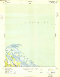 1944 Messick1944 Print · USGSCoastal Virginia at the height of the war reveals a landscape of quiet maritime settlements and active military training grounds. Researchers can trace the layout of Jeffs and Messick alongside the expansive U S Army Bombing Area and Plumtree Island.
 - 1944 Map of Morrison
 1944 Morrison1944 Print · USGSThe Virginia Peninsula is captured here during the height of the Second World War. Genealogists and local historians can trace the development of Hilton Village, identify sites like Big Bethel Battlefield, and locate family-named landmarks such as Curtis Corner.
 - 1944 Map of Harris Grove, 1953 Print
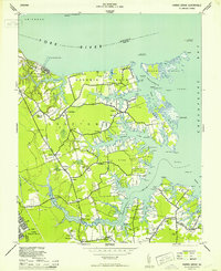 1944 Harris Grove1953 Print · USGSCoastal York County and the Poquoson area are captured here during the height of the Second World War. You can trace military boundaries at Camp Patrick Henry or find family landmarks like Tabb Ch and Cem, St Michaels Ch, and the Poor Farm.
 - 1948 Map of Achilles
 1948 Achilles1948 Print · USGSCoastal Gloucester County is depicted here in the late 1940s, a period defined by the tidewater economy and maritime navigation. Genealogists and historians can trace family locations near Achilles, Naxera, and Maryus, or locate landmarks like Severn Ch and Roanes Wharf.2 unique versions available
 - 1948 Map of New Point Comfort
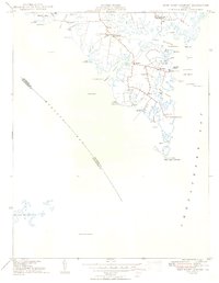 1948 New Point Comfort1948 Print · USGSCoastal Mathews County during the late 1940s reveals a maritime landscape of tidal necks and small harbor settlements. Genealogists and researchers can trace local families through landmarks like Diggs Wharf, Antioch Sch, and the New Point Comfort lighthouse.2 unique versions available
 - 1949 Map of Richmond, 1951 Print
 1949 Richmond1951 Print · USGSCoastal Virginia in the years following World War II remained a landscape of historic river towns and expanding military bases. Genealogists and historians can trace the rail lines of the Southern Ry and locate established landmarks from Camp Lee to the remote reaches of Dragon Swamp.
 - 1950 Map of Cobham Bay, 1953 Print
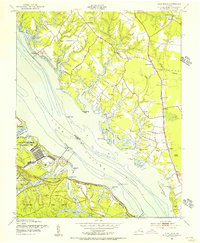
 1950 Cobham Bay1953 Print · USGSThe James River waterfront is frozen in time at mid-century, showing the early boundaries of the Colonial National Historical Monument. Researchers can trace the rural landscape from Jamestown Island to the remote lighthouses at Homewood and Deepwater Shoals.
 - 1950 Map of Yorktown, 1954 Print
 1950 Yorktown1954 Print · USGSThe Virginia Peninsula at the midpoint of the century reveals a landscape where Revolutionary War history meets massive military expansion. Genealogists and historians can trace the footprint of Yorktown alongside mid-century landmarks like the National Cem, Lee Mansion, and the Patrick Henry Airport.
 - 1951 Map of Williamsburg
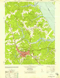
 1951 Williamsburg1951 Print · USGSMid-century Williamsburg and York County reflect a landscape of deep colonial history overlaid by World War II-era military expansion. Researchers can trace the grounds of William and Mary College and the Governors Palace alongside major naval installations like Camp Peary and the Cheatham Annex.
 - 1952 Map of Clay Bank, 1956 Print
 1952 Clay Bank1956 Print · USGSThe York River shoreline in the early fifties shows a fascinating mix of federal defense installations and colonial Virginia heritage. Trace the grounds of Camp Peary and the Yorktown Naval Mine Depot or locate the Powhatan House Ruins.
 - 1952 Map of Williamsburg, 1957 Print
 1952 Williamsburg1957 Print · USGSThe Virginia Peninsula is captured here in the early fifties during a period of heavy military and institutional expansion. Researchers can trace the grounds of William and Mary College, find the Fort Magruder Ruins, and locate forgotten landings like Blaine Landing.
 - 1952 Map of Gressitt, 1957 Print
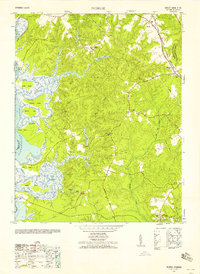
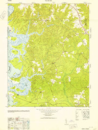
 1952 Gressitt1957 Print · USGSThe Tidewater region of Virginia comes to life in the early fifties, documenting the river-centered life along the YORK RIVER. Researchers can trace family sites in Allmondsville, locate the old Prospect School, or find maritime history at Moodys Old Wharf and Red Bank Landing.
 - 1952 Map of Norge, 1958 Print
 1952 Norge1958 Print · USGSThe Virginia Peninsula comes alive in the early fifties, documenting a world of river landings and small crossroads communities. Genealogists and historians can trace family-named sites like Warren Mill, find the Brickbat School, or locate the Barretta Ferry crossing.
 - 1953 Map of Gressitt
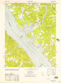
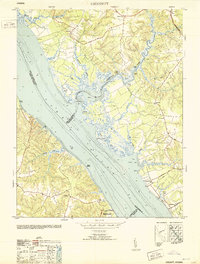 1953 Gressitt1953 Print · USGSThe York River and Poropotank River meet in this Tidewater survey from the early fifties, showing a landscape defined by water and woods. Genealogists and local historians can trace old family landing sites and vanished communities like Gressitt, Adner, and Capahosic.
 - 1953 Map of Norge
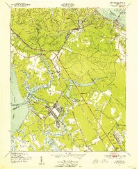
 1953 Norge1953 Print · USGSJames City County is shown in the early fifties as the rural landscape surrounding Norge and Lightfoot began to modernize. Researchers can trace historic river access at Shipyard Landing and locate old community hubs like Warren Mill or Jerusalem Church.
Showing maps 1-25 of 76
Top cities of York County
Frequently asked questions
- What are the different types of historical maps available for York County?
- What is the oldest map of York County?
- Where can I purchase historical maps of York County for my home or office?
- Where can I download high-res historical maps of York County?
- Are there historical topographic maps available for York County?
- Is there historical aerial imagery available for York County?
- Where are historical maps of York County sourced from?