1940s Maps of York County, Virginia
Explore 9 historic maps of York County from the 1940s. These maps offer a rare glimpse into what life looked like during the 1940s — showing old roads, neighborhoods, homes, and landmarks that have changed or disappeared over time.
Whether you're researching your family's past, planning a metal detecting trip, or studying how York County's landscape evolved across the 1940s, these high-resolution maps are a powerful tool for exploring the history of this region.
- Focus on a specific era: All maps on this page are from the 1940s, giving you a focused view of this time period.
- See what’s changed: Compare century-old streets, trails, and buildings to today's modern landscape using overlays and satellite layers.
- Research with precision: Use these maps for genealogy, historical research, land use analysis, or educational projects.
- View, download, or print: Maps are fully viewable online in high resolution, and can be downloaded or printed for your own records.
Start exploring York County's history through authentic maps from the 1940s. This is your window into the past.
York County, VA maps
(9)- 1943 Map of Yorktown
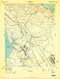
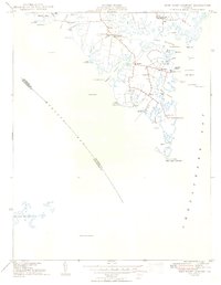
 1943 Yorktown1943 Print · USGSThe Virginia Tidewater is captured here during the Second World War, showing the strategic riverfronts of the James and Warwick rivers. Researchers can locate colonial landmarks and defensive ruins like Old Fort Yorktown, Bacons Castle, and Warwick Courthouse.
 - 1943 Map of Richmond, 1972 Print
 1943 Richmond1972 Print · USGSCoastal Virginia and the state capital are shown in detail during the mid-century era of infrastructure expansion. Genealogists and historians can trace the grounds of Richmond Nat Battlefield Park, locate the Yorktown Nat Cem, or follow the many rural routes through Amelia Court House and Tappahannock.
 - 1944 Map of Yorktown
 1944 Yorktown1944 Print · USGSVirginia's historic Peninsula is captured here during the height of the 1940s mobilization, showing the massive infrastructure of wartime military installations. Researchers can trace the grounds of Fort Eustis and Camp Patrick Henry alongside older landmarks like Old Fort McPherson and Lee Mansion.
 - 1944 Map of Messick
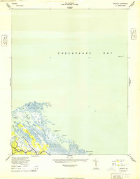 1944 Messick1944 Print · USGSCoastal Virginia at the height of the war reveals a landscape of quiet maritime settlements and active military training grounds. Researchers can trace the layout of Jeffs and Messick alongside the expansive U S Army Bombing Area and Plumtree Island.
 - 1944 Map of Morrison
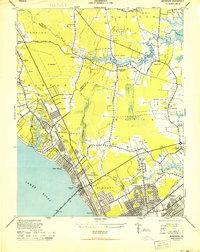 1944 Morrison1944 Print · USGSThe Virginia Peninsula is captured here during the height of the Second World War. Genealogists and local historians can trace the development of Hilton Village, identify sites like Big Bethel Battlefield, and locate family-named landmarks such as Curtis Corner.
 - 1944 Map of Harris Grove, 1953 Print
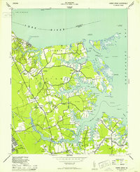 1944 Harris Grove1953 Print · USGSCoastal York County and the Poquoson area are captured here during the height of the Second World War. You can trace military boundaries at Camp Patrick Henry or find family landmarks like Tabb Ch and Cem, St Michaels Ch, and the Poor Farm.
 - 1948 Map of Achilles
 1948 Achilles1948 Print · USGSCoastal Gloucester County is depicted here in the late 1940s, a period defined by the tidewater economy and maritime navigation. Genealogists and historians can trace family locations near Achilles, Naxera, and Maryus, or locate landmarks like Severn Ch and Roanes Wharf.2 unique versions available
 - 1948 Map of New Point Comfort
 1948 New Point Comfort1948 Print · USGSCoastal Mathews County during the late 1940s reveals a maritime landscape of tidal necks and small harbor settlements. Genealogists and researchers can trace local families through landmarks like Diggs Wharf, Antioch Sch, and the New Point Comfort lighthouse.2 unique versions available
 - 1949 Map of Richmond, 1951 Print
 1949 Richmond1951 Print · USGSCoastal Virginia in the years following World War II remained a landscape of historic river towns and expanding military bases. Genealogists and historians can trace the rail lines of the Southern Ry and locate established landmarks from Camp Lee to the remote reaches of Dragon Swamp.
End of results
Showing maps 1-9 of 9
Top cities of York County
Frequently asked questions
- What are the different types of historical maps available for York County?
- What is the oldest map of York County?
- Where can I purchase historical maps of York County for my home or office?
- Where can I download high-res historical maps of York County?
- Are there historical topographic maps available for York County?
- Is there historical aerial imagery available for York County?
- Where are historical maps of York County sourced from?