1990s Maps of York County, Virginia
Explore 3 historic maps of York County from the 1990s. These maps offer a rare glimpse into what life looked like during the 1990s — showing old roads, neighborhoods, homes, and landmarks that have changed or disappeared over time.
Whether you're researching your family's past, planning a metal detecting trip, or studying how York County's landscape evolved across the 1990s, these high-resolution maps are a powerful tool for exploring the history of this region.
- Focus on a specific era: All maps on this page are from the 1990s, giving you a focused view of this time period.
- See what’s changed: Compare century-old streets, trails, and buildings to today's modern landscape using overlays and satellite layers.
- Research with precision: Use these maps for genealogy, historical research, land use analysis, or educational projects.
- View, download, or print: Maps are fully viewable online in high resolution, and can be downloaded or printed for your own records.
Start exploring York County's history through authentic maps from the 1990s. This is your window into the past.
York County, VA maps
(3)- 1994 Map of Yorktown, 1999 Print
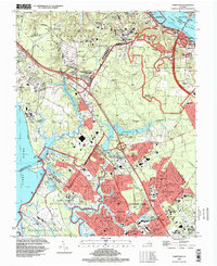 1994 Yorktown1999 Print · USGSThe Virginia Peninsula near the end of the century reveals a strategic landscape where colonial history meets modern military power. Genealogists and historians can trace Yorktown National Cemetery, the Surrender Ground, and family-named landmarks like Curtis Cem and Hanover Heights.
 - 1994 Map of Norge, 2000 Print
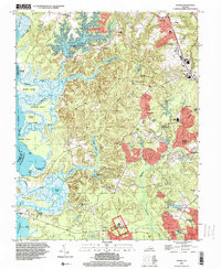 1994 Norge2000 Print · USGSJames City County was undergoing suburban growth in the 1990s while preserving its deep colonial roots. Researchers can trace historic foundations at Green Spring Ruins and locate community landmarks like James City Chapel Cem and Norge.
 - 1999 Map of Hog Island, 2001 Print
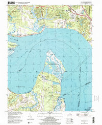 1999 Hog Island2001 Print · USGSThe James River shoreline near Williamsburg is captured here in the late nineties, documenting a landscape where colonial heritage meets modern industry. Researchers can trace historic sites like Jamestown Island and Travis Cem alongside the Surry Nuclear Powerplant.
End of results
Showing maps 1-3 of 3
Top cities of York County
Frequently asked questions
- What are the different types of historical maps available for York County?
- What is the oldest map of York County?
- Where can I purchase historical maps of York County for my home or office?
- Where can I download high-res historical maps of York County?
- Are there historical topographic maps available for York County?
- Is there historical aerial imagery available for York County?
- Where are historical maps of York County sourced from?