1950s Maps of York County, Virginia
Explore 17 historic maps of York County from the 1950s. These maps offer a rare glimpse into what life looked like during the 1950s — showing old roads, neighborhoods, homes, and landmarks that have changed or disappeared over time.
Whether you're researching your family's past, planning a metal detecting trip, or studying how York County's landscape evolved across the 1950s, these high-resolution maps are a powerful tool for exploring the history of this region.
- Focus on a specific era: All maps on this page are from the 1950s, giving you a focused view of this time period.
- See what’s changed: Compare century-old streets, trails, and buildings to today's modern landscape using overlays and satellite layers.
- Research with precision: Use these maps for genealogy, historical research, land use analysis, or educational projects.
- View, download, or print: Maps are fully viewable online in high resolution, and can be downloaded or printed for your own records.
Start exploring York County's history through authentic maps from the 1950s. This is your window into the past.
York County, VA maps
(17)- 1950 Map of Cobham Bay, 1953 Print
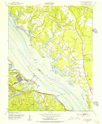
 1950 Cobham Bay1953 Print · USGSThe James River waterfront is frozen in time at mid-century, showing the early boundaries of the Colonial National Historical Monument. Researchers can trace the rural landscape from Jamestown Island to the remote lighthouses at Homewood and Deepwater Shoals.
 - 1950 Map of Yorktown, 1954 Print
 1950 Yorktown1954 Print · USGSThe Virginia Peninsula at the midpoint of the century reveals a landscape where Revolutionary War history meets massive military expansion. Genealogists and historians can trace the footprint of Yorktown alongside mid-century landmarks like the National Cem, Lee Mansion, and the Patrick Henry Airport.
 - 1951 Map of Williamsburg
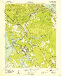
 1951 Williamsburg1951 Print · USGSMid-century Williamsburg and York County reflect a landscape of deep colonial history overlaid by World War II-era military expansion. Researchers can trace the grounds of William and Mary College and the Governors Palace alongside major naval installations like Camp Peary and the Cheatham Annex.
 - 1952 Map of Clay Bank, 1956 Print
 1952 Clay Bank1956 Print · USGSThe York River shoreline in the early fifties shows a fascinating mix of federal defense installations and colonial Virginia heritage. Trace the grounds of Camp Peary and the Yorktown Naval Mine Depot or locate the Powhatan House Ruins.
 - 1952 Map of Williamsburg, 1957 Print
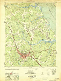
 1952 Williamsburg1957 Print · USGSThe Virginia Peninsula is captured here in the early fifties during a period of heavy military and institutional expansion. Researchers can trace the grounds of William and Mary College, find the Fort Magruder Ruins, and locate forgotten landings like Blaine Landing.
 - 1952 Map of Gressitt, 1957 Print
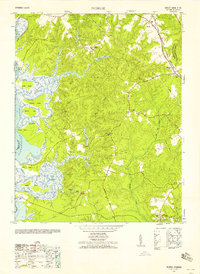
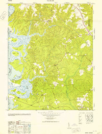
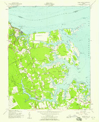
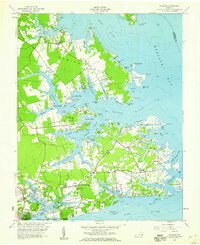
 1952 Gressitt1957 Print · USGSThe Tidewater region of Virginia comes to life in the early fifties, documenting the river-centered life along the YORK RIVER. Researchers can trace family sites in Allmondsville, locate the old Prospect School, or find maritime history at Moodys Old Wharf and Red Bank Landing.
 - 1952 Map of Norge, 1958 Print
 1952 Norge1958 Print · USGSThe Virginia Peninsula comes alive in the early fifties, documenting a world of river landings and small crossroads communities. Genealogists and historians can trace family-named sites like Warren Mill, find the Brickbat School, or locate the Barretta Ferry crossing.
 - 1953 Map of Gressitt
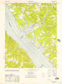
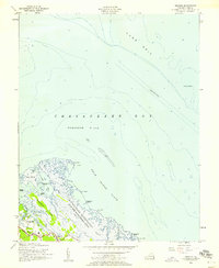
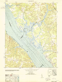 1953 Gressitt1953 Print · USGSThe York River and Poropotank River meet in this Tidewater survey from the early fifties, showing a landscape defined by water and woods. Genealogists and local historians can trace old family landing sites and vanished communities like Gressitt, Adner, and Capahosic.
 - 1953 Map of Norge
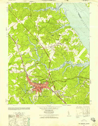
 1953 Norge1953 Print · USGSJames City County is shown in the early fifties as the rural landscape surrounding Norge and Lightfoot began to modernize. Researchers can trace historic river access at Shipyard Landing and locate old community hubs like Warren Mill or Jerusalem Church.
 - 1955 Map of Morrison, 1958 Print
 1955 Morrison1958 Print · USGSMid-century development spreads across the Virginia Peninsula in the years following the war, bridging the gap between old battlefields and new suburbs. Genealogists and historians can trace neighborhood growth through Hilton Village, Aberdeen Garden, and the location of Blooming Zion Ch.
 - 1955 Map of Harris Grove, 1958 Print
 1955 Harris Grove1958 Print · USGSThe Virginia Peninsula is captured here in the mid-fifties, showing the coastal necks and historical grounds around the York River. Genealogists and historians can trace the footprint of Yorktown Battlefield, the community of Poquoson, and local landmarks like Moore House.
 - 1955 Map of Messick, 1958 Print
 1955 Messick1958 Print · USGSCoastal York County in the mid-fifties is defined by the intersection of military zones and small tidewater communities. Local historians can trace the early layout of Poquoson and Messick alongside the Plum Tree Island Bombing Range and the lonely York Spit Lighthouse.
 - 1957 Map of Cobham Bay, 1960 Print
 1957 Cobham Bay1960 Print · USGSThe James River coastline in the late fifties was a mix of historic preservation and active military defense. Trace the development of Hog Island State Waterfowl Refuge and locate old family sites like Travis Cem and Chippokes.
 - 1957 Map of New Point Comfort, 1960 Print
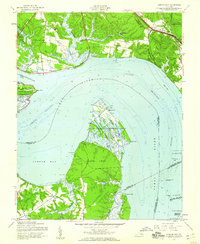
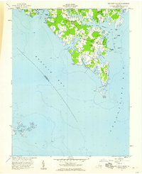 1957 New Point Comfort1960 Print · USGSThe tip of the Mathews peninsula comes into focus during the late fifties, showing a landscape defined by tidal creeks and maritime settlements. Genealogists and historians can trace family locations near Antioch Ch, find the historic Lighthouse New Point Comfort, and locate old landing sites like Diggs Wharf.
 - 1957 Map of Achilles, 1960 Print
 1957 Achilles1960 Print · USGSGloucester County's tidal peninsulas are captured here in the late fifties, showcasing a landscape of waterside landings and rural parishes. Genealogists can trace family sites from Warner Hall to coastal settlements like Maryus, Achilles, and Bena.
 - 1957 Map of Yorktown, 1960 Print
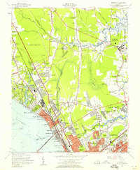
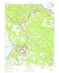 1957 Yorktown1960 Print · USGSThe Virginia Peninsula is shown here during a period of significant military and suburban growth in the late fifties. Researchers can trace the layout of Fort Eustis, the historic streets of Yorktown, and local landmarks like Rising Sun Church or the Patrick Henry Airport.
 - 1959 Map of Richmond
 1959 Richmond1959 Print · USGSMid-century Virginia is captured here at its most vital rail and river junctions, from the capital city to the Chesapeake Bay. Genealogists and historians can trace the development of colonial settlements like Williamsburg and military landmarks including Fort Monroe and Camp Lee.
End of results
Showing maps 1-17 of 17
Top cities of York County
Frequently asked questions
- What are the different types of historical maps available for York County?
- What is the oldest map of York County?
- Where can I purchase historical maps of York County for my home or office?
- Where can I download high-res historical maps of York County?
- Are there historical topographic maps available for York County?
- Is there historical aerial imagery available for York County?
- Where are historical maps of York County sourced from?