1980s Maps of York County, Virginia
Explore 9 historic maps of York County from the 1980s. These maps offer a rare glimpse into what life looked like during the 1980s — showing old roads, neighborhoods, homes, and landmarks that have changed or disappeared over time.
Whether you're researching your family's past, planning a metal detecting trip, or studying how York County's landscape evolved across the 1980s, these high-resolution maps are a powerful tool for exploring the history of this region.
- Focus on a specific era: All maps on this page are from the 1980s, giving you a focused view of this time period.
- See what’s changed: Compare century-old streets, trails, and buildings to today's modern landscape using overlays and satellite layers.
- Research with precision: Use these maps for genealogy, historical research, land use analysis, or educational projects.
- View, download, or print: Maps are fully viewable online in high resolution, and can be downloaded or printed for your own records.
Start exploring York County's history through authentic maps from the 1980s. This is your window into the past.
York County, VA maps
(9)- 1983 Map of Poquoson West
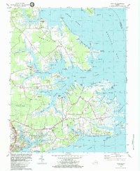
 1983 Poquoson West1983 Print · USGSThe York County coast in the early 1980s reveals a unique blend of Revolutionary War heritage and modern industrial growth. Genealogists and historians can trace family-named sites like Hornsbysville and Moores alongside battle trenches and the Harwoods Mill site.2 unique versions available
 - 1983 Map of Achilles
 1983 Achilles1983 Print · USGSThe coastal peninsulas of Gloucester County appear in high detail during the early 1980s, showcasing a landscape shaped by tidal rivers and small harbors. Genealogists can trace family roots through sites like Groves Memorial Ch, Severn Wharf, and the rural settlement of Achilles.2 unique versions available
 - 1984 Map of Norge
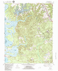 1984 Norge1984 Print · USGSJames City County is shown here in the mid-1980s, capturing a blend of colonial heritage sites and modern residential expansion. Genealogists and historians can trace the Green Spring Ruins, locate old congregations at James City Chapel, and explore the shoreline from Shields Point to Claybank Landing.3 unique versions available
 - 1984 Map of Hog Island
 1984 Hog Island1984 Print · USGSThe James River shoreline near Williamsburg is a landscape where colonial history meets modern energy in the mid-eighties. Genealogists and historians can trace the grounds of the Kingsmill Plantation Site, Travis Cem, and Carters Grove Historical Home.2 unique versions available
 - 1984 Map of Yorktown
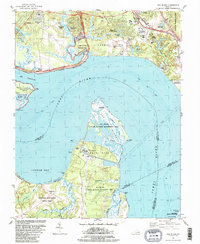
 1984 Yorktown1984 Print · USGSYorktown and the Virginia Peninsula are shown in the mid-eighties as a unique blend of National Park sites and active military installations. Researchers can trace historic landmarks like Cornwallis Cave, Washingtons Headquarters, and the Surrender Ground alongside the growth of Lee Hall.2 unique versions available
 - 1984 Map of Williamsburg
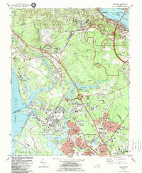
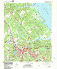 1984 Williamsburg1984 Print · USGSCovers York County, including Williamsburg, Oaktree, and other nearby areas2 unique versions available
 - 1984 Map of Clay Bank
 1984 Clay Bank1984 Print · USGSThe York River shoreline in the mid-eighties shows a landscape of strategic naval bases and historic Virginia tidewater settlements. Genealogists and local historians can trace family roots at Abingdon Ch, the Bellfield Plantation Site, and White Marsh.3 unique versions available
 - 1984 Map of Williamsburg, 1985 Print
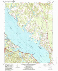
 1984 Williamsburg1985 Print · USGSThe Virginia Peninsula and Chesapeake Bay shores are shown in the mid-1980s, revealing a landscape defined by colonial heritage and massive military installations. Researchers can trace the grounds of the College of William and Mary, the Yorktown National Cemetery, and the historic Jamestown Island.3 unique versions available
 - 1986 Map of East of Poquoson East, 1987 Print
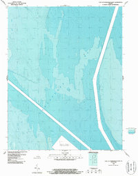 1986 East of Poquoson East1987 Print · USGSThe waters of the Chesapeake Bay are charted in detail in the mid-1980s, revealing the floor of the Virginia coast. Maritime researchers and historians can trace depth gradients and identify a Spoil Area Discontinued east of the shoreline.
End of results
Showing maps 1-9 of 9
Top cities of York County
Frequently asked questions
- What are the different types of historical maps available for York County?
- What is the oldest map of York County?
- Where can I purchase historical maps of York County for my home or office?
- Where can I download high-res historical maps of York County?
- Are there historical topographic maps available for York County?
- Is there historical aerial imagery available for York County?
- Where are historical maps of York County sourced from?