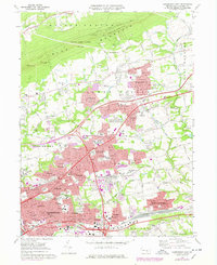
1969 Map of Harrisburg East
USGS Topo · Published 1977About this map
Blue Mountain and the State Game Lands No 246 dominate the northern landscape of this Dauphin County region, while the southern half shows the rapid suburban expansion of eastern Harrisburg in the late 1960s and mid-1970s. The map captures a high density of civic and religious infrastructure, including several cemeteries like Harrisburg Cemetery and Shoops Cemetery, alongside numerous educational institutions such as Central Dauphin High School and Central Dauphin East High School.
Find a feature on this map
90 named features on this map. Tap any name to fly to it.
Don’t see what you’re looking for? This feature index may not catch every label — zoom into the map to look around manually.
Map Details
Editions of this 1969 Harrisburg East Map
Other maps of this area

1892 · Hummelstown
USGS Topo · 1:62,500

1892 · Harrisburg
USGS Topo · 1:62,500

1899 · Harrisburg
USGS Topo · 1:62,500

1906 · New Cumberland
USGS Topo · 1:62,500

1908 · Middletown
USGS Topo · 1:62,500

1924 · Hummelstown
USGS Topo · 1:62,500

1924 · Harrisburg
USGS Topo · 1:62,500

1943 · New Cumberland
USGS Topo · 1:62,500

1943 · Middletown
USGS Topo · 1:62,500

1943 · Harrisburg
USGS Topo · 1:62,500
Featured Places
- Harrisburg, PA
- Colonial Park, Lower Paxton Township
- Progress, Susquehanna Township
- Linglestown, Lower Paxton Township
- Rutherford, Swatara Township