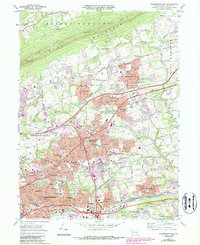
1969 Map of Harrisburg East
USGS Topo · Published 1987About this map
Blue Mountain forms a prominent northern boundary to this landscape, while the southern reaches show the intense post-war expansion of Harrisburg and its surrounding townships. The suburban growth of the late 1960s is evident in the sprawling residential developments of Colonial Park and Progress, contrasted against the older established boroughs like Paxtang and Penbrook. The map captures a high concentration of civic and social infrastructure, from the large State Hospital complex to numerous local institutions such as Holy Name of Jesus Ch and the County Home and Hospital.
Find a feature on this map
81 named features on this map. Tap any name to fly to it.
Don’t see what you’re looking for? This feature index may not catch every label — zoom into the map to look around manually.
Map Details
Editions of this 1969 Harrisburg East Map
Other maps of this area

1892 · Hummelstown
USGS Topo · 1:62,500

1892 · Harrisburg
USGS Topo · 1:62,500

1899 · Harrisburg
USGS Topo · 1:62,500

1906 · New Cumberland
USGS Topo · 1:62,500

1908 · Middletown
USGS Topo · 1:62,500

1924 · Hummelstown
USGS Topo · 1:62,500

1924 · Harrisburg
USGS Topo · 1:62,500

1943 · New Cumberland
USGS Topo · 1:62,500

1943 · Middletown
USGS Topo · 1:62,500

1943 · Harrisburg
USGS Topo · 1:62,500
Featured Places
- Harrisburg, PA
- Colonial Park, Lower Paxton Township
- Progress, Susquehanna Township
- Linglestown, Lower Paxton Township
- Rutherford, Swatara Township