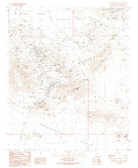
1990 Map of Harrisburg Valley
USGS Topo · Published 1990About this map
Harquahala Mountains and the Little Harquahala Mountains dominate this arid landscape, where the legacy of desert prospecting is written in hundreds of prospects and mine shafts. The most intensive activity centers on the Harquahala Mine and Golden Eagle Mine, which mark the epicenter of a hard-scrabble mineral economy. In the valleys between the peaks, human presence is sparse but deliberate, from the isolated Nords Ranch to a lonely Landing Strip and a small Cem tucked away from the main washes. Notable geographic markers like The Needle and Natural Arch provide critical orientation points in the terrain. The presence of Centennial Wash and various check dams suggests the seasonal importance of water management in a region defined by the vast Mc Mullen Valley and the southern Harquahala Plain.
Find a feature on this map
29 named features on this map. Tap any name to fly to it.
Don’t see what you’re looking for? This feature index may not catch every label — zoom into the map to look around manually.
Map Details
Editions of this 1990 Harrisburg Valley Map
This is the sole edition of this map. No revisions or reprints were ever made.
Other maps of this area

1942 · Vicksburg
USGS Topo · 1:250,000

1954 · Phoenix
USGS Topo · 1:250,000

1957 · Phoenix
USGS Topo · 1:250,000

1958 · Phoenix
USGS Topo · 1:250,000

1960 · Phoenix
USGS Topo · 1:250,000

1961 · Salome
USGS Topo · 1:62,500

1961 · Hope
USGS Topo · 1:62,500

1961 · Lone Mountain
USGS Topo · 1:62,500

1961 · Gladden
USGS Topo · 1:62,500

1969 · Phoenix
USGS Topo · 1:250,000