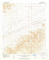
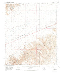
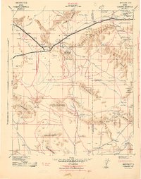
1961 Map of Gladden
USGS Topo · Published 1963About this map
The Harquahala Mountains dominate this southwestern desert landscape, rising sharply from the basin floor and sheltering a series of remote mining operations. The southern half of the map reveals a history of extraction, featuring the White Marble Mine, Silver Queen Mine, and the Hidden Treasure Mine scattered across the high slopes near Harquahala Mtn. This period of Arizona's development was defined by the transition from hard-rock prospecting to the modernization of infrastructure, as evidenced by the high-voltage transmission line and the Eagle Eye Substation cutting across the valley.
Find a feature on this map
43 named features on this map. Tap any name to fly to it.
Don’t see what you’re looking for? This feature index may not catch every label — zoom into the map to look around manually.
Map Details
Editions of this 1961 Gladden Map
3 editions found

Other maps of this area

1923 · Signal
USGS Topo · 1:250,000

1942 · Signal
USGS Topo · 1:250,000
1942 · Vicksburg
USGS Topo · 1:250,000

1950 · Prescott
USGS Topo · 1:250,000

1954 · Prescott
USGS Topo · 1:250,000

1954 · Phoenix
USGS Topo · 1:250,000

1957 · Phoenix
USGS Topo · 1:250,000

1958 · Prescott
USGS Topo · 1:250,000

1958 · Phoenix
USGS Topo · 1:250,000

1959 · Prescott
USGS Topo · 1:250,000